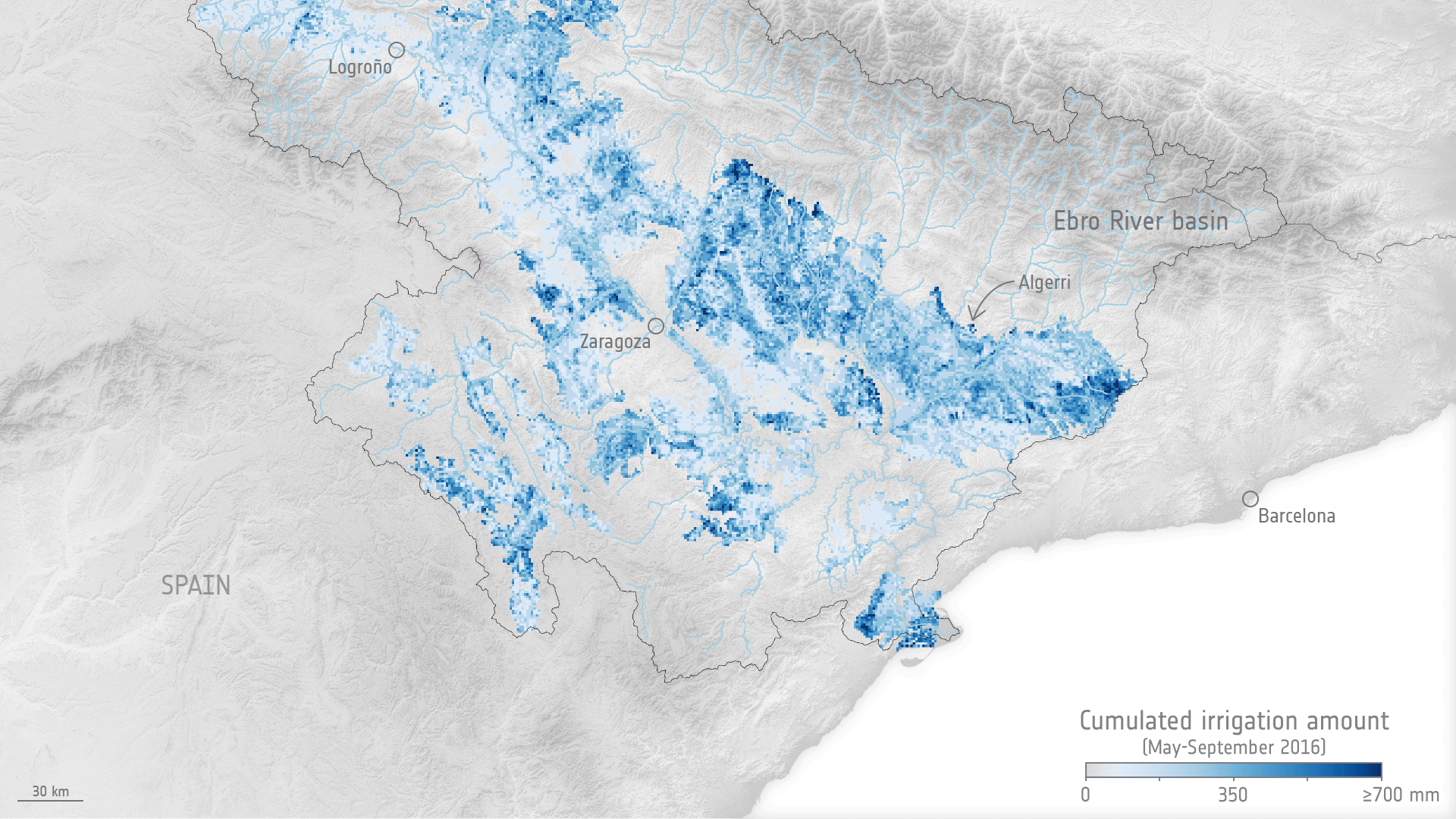
Tag: agriculture
EOAFRICA Webinar: fPAR as a Proxy for Yield Estimation/Forecasting
The webinar provides a biological basis for crop yield estimation and within-season forecasting with Earth observation image data. The webinar will be executed under the framework of the EO AFRICA R&D Facility by the University of Twente – Faculty of Geoinformation Science and Earth Observation.
TAVAP: Timing and Variable Application of Plant Growth Regulators
Prime company: World from Space (CZ)Variable application of fertilizers based on remote sensing data analysis has become popular among farmers focussing on smart agriculture. Some farmers and companies are in similar manner using variable seeding strategies, in order to save costs and improve yields. Variable application of plant growth regulators is a promising step towards precision agriculture. A growth regulator, …
EO AFRICA Food Security and Safety in Africa – AFRI4Cast
Prime company: AGROAPPS PC (GR)Afri4Cast project will develop a modeling platform making full exploitation of satellite remote sensing of PRISMA and ECOSTRESS sensors for climate change impact analyses on agriculture and making it available to African stakeholders for shaping future agricultural policies in the African Continent. Afri4Cast will provide national-, regional-, parcel-, pixel-specific in season production estimates, mycotoxin formation …
EO AFRIca multi-scale SMART agricultural water management – AFRI-SMART
Prime company: POLITECNICO DI MILANO (IT)The project investigates how sustainable agriculture can be achieved in the Africa continent under drought conditions, by co-developing innovative scientific EO-based and state-of-the-art modelling solutions together with African experts increasing their knowledge and capacity, developing an operative platform and database for results visualization and sharing with the end-users.
EO AFRICA Integrated use of multisource remote sensing data for national scale Agricultural Drought Monitoring in Kenya (ADM-Kenya)
Prime company: Leibniz Centre for Agricultural Landscape Research (ZALF) (DE)ADM Kenya project aims to co-develop solutions for monitoring crop condition and cropping systems with EO time-series observations to derive evidence-based quantitative vegetation condition estimates with high spatial and temporal resolution. We will develop novel EO-based solutions for drought monitoring at a national scale in Kenya. ADM Kenya will provide cloud-based processing algorithms that will …
EO AFRICA Earth Observation system to Manage Africa’s food systems by Joint-knowledge of crop production and Irrigation digitization – EO-MAJI
Prime company: UNIVERSITY OF LEICESTER (GB)Primary objective of this project is to utilize the unique spatial, spectral and temporal characteristics of ECOSTRESS thermal sensor and PRISMA hyperspectral sensor to develop novel methods addressing the growing challenges affecting the nexus of water resource management and food security in Africa. Irrigated agriculture is right in the centre of those two domains and …
11th Advanced Training Course on Land Remote Sensing
Background The European Space Agency (ESA) is organising an Advanced Training Course on Land Remote Sensing with the focus on Agriculture and Water in collaboration with the Institute of Advanced Studies Kőszeg (iASK). This course is dedicated to training the next generation of Earth Observation (EO) scientists and experts working in Agriculture and Water domain to exploit data …
AI4FOOD
Prime company: VLAAMSE INSTELLING VOOR TECHNOLOGISCH ONDERZOEK VITO (BE)An unprecedented richness of data is captured by satellites every day, resulting in an ever-growing time series of EO data. Despite the extensive availability of data, there are still many challenges when defining procedures for extracting relevant information from long time series. The goal of the AI4FOOD project is to tackle the challenges that arise …
EO AFRICA F2F Training #5: Cloud based EO analyses for Water and Food Security
The 5th F2F course of the EO AFRICA R&D Facility will take place in Nairobi, Kenya in close collaboration with the Regional Centre for Mapping of Resources or Development (RCMRD). In this course, participants will get an introduction to cloud-based image analysis techniques for Water and Food Security. The training includes face-to-face lecturing and reading …