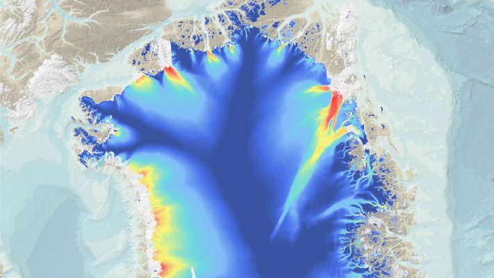
Enhanced Satellite Derived Bathymetry (SDB) with Sentinel-2
Thanks to the work performed within the Sentinel coastal charting worldwide project, the effectiveness of Sentinel-2 data for bathymetry mapping has been proven. Read the full story.
The movie above is demonstrating how the QuantEO service may be used to detect water over time in Sub Saharan Africa from Senegal to Ethiopia. This is a sample application of the service, developed by Pixstart within an Open Call project, which allows to produce classified Sentinel-2 images on demand and near real time …
Methane continues to increase in our atmosphere, and now researchers want to quantify the role of high Northern latitudes to this increase. Earth-observing satellites open the window to this remote, rapidly changing environment. Carbon cycle in the Arctic and boreal regions links strongly to the evolving cryosphere – ice, snow and frost. Especially natural methane …
Since 2011, sargassum rafts of unprecedented size have had been found on Caribbean shores, with a strong impact on tourism, fisheries and wildlife. As sargassum decomposes on beaches, it releases disagreeable odours. Removal is time-consuming and expensive as mats can be several meters thick. Tourists are bothered by sargassum, and incoming rafts smother sea grasses …
Incomplete avalanche activity datasets introduce uncertainty to avalanche forecasting Roughly 150-250 people die each year in avalanche accidents. Infrastructure loss and costs from evacuations and road closures and the use of active and permanent mitigation measures amount to large economic costs. Regional avalanche forecasting is an active mitigation measure that informs the public of …