Land remote sensing: training material
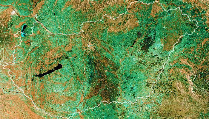
Access training material from 7th Advanced Training Course on Land Remote Sensing 2017 held in Hungary.
Access training material from 7th Advanced Training Course on Land Remote Sensing 2017 held in Hungary.
The magnetic field is arguably one of the most mysterious features of our planet. ESA’s Swarm mission is continually yielding more insight into how our protective shield is generated, how it behaves and how it is changing. Adding yet another string to its bow, Swarm is now tracking changes in the magnetic field produced in …

The 4 competing DIAS platforms offer Sentinel data readily available on the cloud, just bring your algorithm and deploy it to process huge volumes of data. Learn more details on http://copernicus.eu/news/copernicus-dias-contracts-signed and follow the Copernicus news for the latest updates The service will be available from mid-2018.
Endless sunshine, eternal summer: the Sentinel-2 cloudless layer combines over 80 trillion pixels collected during differing weather conditions between May 2016 and April 2017, and merges them into a sunny homogeneous mosaic, (almost) free from atmospheric impacts. Sentinel-2 cloudless by EOX IT Services GmbH is licensed under a Creative Commons Attribution 4.0 International License.
The OGC EO Interface Integration Service provides users with OGC web service API access to Sentinel-1, Sentinel-2, Sentinel-3, Landsat, MODIS and ENVISAT MERIS EO Data Repository, constantly updated with fresh products from Sentinel and Landsat satellites. Depending on the service type requested, such direct access and related functionality (e.g. cropping, masking, band selection, band math) allows …
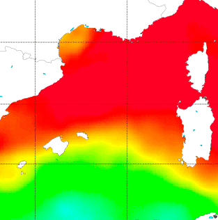
Data from Soil Moisture and Ocean Salinity (SMOS) mission can help to gain a better understanding of the Sea Surface Salinity (SSS) dynamics in the Mediterranean Sea, a hotspot for climate change. Unfortunately, this critical area is strongly affected by Radio Frequency Interference (RFI) and systematic biases due to the coast contamination (also called Land-Sea …
An online environment has been developed in the last few years for oceanographers to discover the existence of all available and co-located EO and related model/in-situ datasets and to handle them jointly in a convenient, flexible and intuitive way. The current version includes more than 350 datasets and is mostly focused on the Agulhas region. …
See how Earth Observation supports water resource managers worldwide in the video produced by the EO4SD Water Resources team, and learn more about ESA initiatives for safeguarding water in this article. Watch the video in English: in French: and in Spanish:
ESA has launched a tender, Sen4CAP, which will provide us useful knowledge and further possibilities on how we use Sentinel data in the context of the Common Agricultural Policy
Last 16th January, an initial exploratory meeting took place at ESRIN to start a discussion on EO and Official Development Assistance (ODA) with first interested national aid agencies from across Europe, together with representatives from the national space agencies/government departments, the OECD and DG-DEVCO. To date, the activities of ESA in the development aid area …