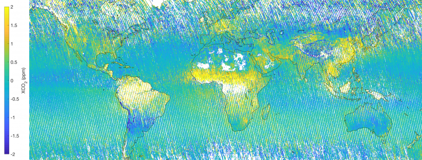
Diego Loyola – Sentinel-5P
The unprecedented spatial resolution offered by Copernicus Sentinel-5P’s Tropomi instrument means that we can now better analyse the complex relationship between tropospheric ozone and climate.
The loss of ice from Antarctica is one of the principal causes of contemporary sea level rise. Tracking the changes that are currently occurring across this remote and inaccessible continent requires systematic satellite monitoring programmes. From these unique observational platforms, robust long-term climate records can be developed, which help scientists to understand and to predict …
A good aircraft heating was necessary to secure proper functioning of the on-board instrumentation during the airborne campaign that took place last November in the Arctic, flying between Ottawa and Iqaluit. The campaign exploited several radars and lidars to measure cloud particles and precipitation by looking at signals bouncing off ice crystals and water droplets …
The possibility to operationally monitor the Earth’s land cover (changes) at high temporal resolution is nowadays given by EO multispectral dense time series available at global level, in particular Sentinel-2 and Landsat 8 data. Nonetheless, keeping thematic maps regularly updated is a complex and time consuming task. Large efforts have been devoted to date in …
Regional sea level trends present large spatial patterns caused by natural variability (changes in winds, air-sea flux etc.) along with anthropogenic influences in the atmosphere. These sea level trends can be partially masked by random oceanic processes. Global mean sea level rise is one of the most direct consequences of the on-going global warming. Based …
High atmospheric CO2 levels may lead to acidification of the ocean with severe consequences on marine ecosystems. Estimates of CO2 fluxes at the air-sea interface strongly depend on the availability of partial pressure of CO2 at the surface ocean (pCO2), which is a critical parameter for a detailed study of the mechanisms involved in the ocean-atmosphere CO2 …
An exciting week, bringing to ESA-ESRIN in Italy hundreds of participants from all over the world to explore innovation, new technologies and cross-disciplinary cooperation, just came to an end. Replay at your pace the ESA video highlights and the live streamed sessions, directly accessible from the agenda: Monday 12 November 09:00–10:30 Opening Session – Space …
GOCE gravity images are revolutionising our ability to study the least understood continent on Earth, Antarctica
The combination of seismological and satellite gravity gradient imaging enhance our knowledge of Earth’s structure, especially in remote areas like the Antarctic continent, where even basic knowledge of lithospheric scale features is incomplete. A research team from Kiel University and the British Antarctic Survey exploited the satellite gravity gradients measured from 2009 to 2013 by …
Royal Research Ship James Clark Ross started its roughly 4000 miles, 40 days voyage across the Atlantic Ocean at the end of September. It has been carrying out in situ measurements with an array of instruments including above-water radiometric optical sensors that measure upwelling radiance from the sea surface for validation of satellite ocean colour, …