APEx: streamlining, from EO innovation to operations
11 April 2025
It’s a great time to work in Earth Observation, with an unprecedented number of missions acquiring […]
Allow the community to share data and algorithms on platforms and get support in hosting their algorithms on the clouds. You can find the current public available operational offering on the NoR Discovery Portal
A number of platforms were developed and continue to evolve according to your needs with ESA support.
Find in this page news updates and direct access links.

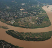
C-TEP is a data access service dedicated to improving the efficiently of data-intensive research into our dynamic coastal areas

The FS-TEP offers on-line processing services and tools to support sustainable food production from space

The F-TEP offers on-line processing services and tools to generate value-added forest information products
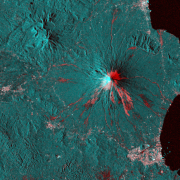
The Geohazards Exploitation Platform enables the exploitation of satellite EO data to support the geohazard community
The H-TEP offers the hydrology community the opportunity to exchange data, services and knowledge through a common collaboration framework
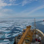
The Polar TEP provides polar researchers access to computing resources, EO data and software tools in the cloud

The TEP Urban platform is providing data, methods and infrastructure to help creating sustainable urban environments