Scarcity of water resources is today a real issue in some geographic areas. Temperatures have increased by 0,85°C on average between 1880 and 2012 and could reach 4,8°C increase by 2100 compared to the period 1986-2005, according to the latest IPCC report. As one of the consequences, agriculture and viticulture are facing droughts at the same time as a growing demand. Such increasing pressure makes it necessary to optimize available water resources without losing neither yield production nor quality.
Vine irrigation has been used for a very long time in the so-called “new world” vineyards (Australia, Argentina, United States – California – and Chile) and is widely practiced there. Its adoption in the Mediterranean region is much more recent and is one of the first adaptations of wine growers to the consequences of climate change (Ojeda and Saurin, 2014).
Irrigation and water stress management of grapevines is essential in arid and semi-arid areas with limited water supply to maintain both the quality and quantity of the harvest. This has led the scientific community and companies to develop new technologies for irrigation control, allowing to rationalize the inputs according to the needs of the crop.
WineEO: a project to help optimize irrigation with remote monitoring of vineyards
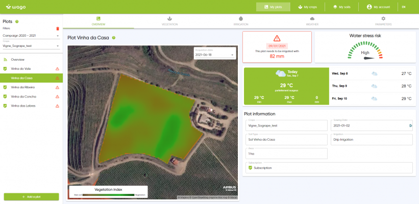
The WineEO project, funded via the ESA Open Call mechanism, is a step in this direction by developing an operational irrigation scheduling service for winegrowers. This service, named Wago, is based on a water balance model mixing three data sources: satellite imagery (Copernicus Sentinel-2 optical images), in situ data and meteorological data. It provides farmers with irrigation recommendations (when, where and how much water to apply over the vineyard).
Two main challenges are faced by this project:
(1) Adapting the existing water balance model developed by Cesbio to vine specificities. In contrast to annual crops, vines are characterized by a cover sparsity and a large variability of geometry (rows, inter-rows, vegetation height): this generates the need to work on the water balance model itself and on the resolution of Sentinel-2 images.
(2) Developing a user friendly platform to allow winegrowers to access Wago products.
The project is led by TerraNIS, a SME based in France which is in charge of the industrialization and commercialization of the service. Cesbio, a French laboratory, is adapting the water balance model embedded in Wago. Finally, four end-users are targeted in four different countries – Portugal, Italy, Spain and Chile – to test the application in different agronomic conditions (soil, climate, agricultural practices, etc.).
A user friendly web application for winegrowers
Based on end-users specifications, TerraNIS is developing a service to optimize vine irrigation by providing winegrowers with stress indicators and agronomic advice through a web interface and a mobile application.
Its “engine” water balance model, adapted to wine specificities, is fed on a daily basis with several meteorological data, such as rainfall and potential evapotranspiration, as well as with regular Sentinel-2 acquisitions. For each acquisition, a vegetation cover map is produced to highlight the heterogeneity (or homogeneity) of the crop and follow the development of vegetation. The green cover fraction (fCover) retrieved from satellite images is a key indicator used in the agronomical model. For each pixel of the field, it gives the share of bare soil and vegetation. This percentage is then used to estimate soil water evaporation and crop water transpiration.
The web interface is easy to use: users just need to log in and specify parcels boundaries, indicate the crop type, select the soil and specify the sowing date. They will then have access to Wago products including (1) vegetation indicators with maps and statistics (used to identify heterogeneity or abnormal plant vigour for instance), (2) water stress indicators such as the amount of available water in the soil and (3) weather data. When the water stress is high (high water depletion) a recommendation of irrigation is provided (e.g. “It is recommended to irrigate 35mm.”). The main innovative feature of the solution is to be fully remote and automated thanks to interoperability with meteorological and satellite data providers; it gives daily irrigation recommendations to optimize water management.
Increasing Sentinel-2 resolution for higher accuracy
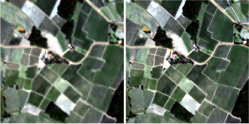
Optical satellite images are used to determine the growth state of vineyards thanks to the correlation between reflectance values and the biophysical characteristics of the vines. SPOT6/7 and Pléiades images are generally used at key dates of the vine life cycle to extract vigour maps. However, these images cannot be used for a regular monitoring of vineyards as their acquisition must be programmed in advance which makes them a costly candidate. In this context, Sentinel-2 images are characterized by high spatial and spectral resolutions which makes them a good candidate for the temporal monitoring of vineyards. Nonetheless, the spatial resolution of Sentinel-2 bands is not ideal for their use in precision viticulture due to the intra-variability of the plots. Advances in Deep Learning in the field of Computer Vision allows enhancing the spatial resolution of these images by using single image super-resolution (SISR) techniques. In the WineEO project, a deep learning SISR was developed to recover a super-resolved Sentinel-2 image at 2.5m in the visible and near-infrared part of the spectrum from its low resolution counterpart as shown in the figure below.
Adapting the water balance model to the vineyard characteristics
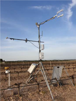
The model initially developed by CESBIO (France) in partnership with UCAM (Morocco), SAT IRR, is mostly effective for one dimensional crops like maize or wheat. In order to study vineyards, and improve the estimation of the evapotranspiration fluxes, it is necessary to take into account the crop geometry. The scientific literature suggests the computation of a double water budget – one for the inter-row, and one for vineyard row – as a solution. In this way the model will calculate the new evapotranspiration of the crop. In order to validate this new model, an experimental design has been setup for in situ evaluation of the energy budget, soil moisture and leaf area index in a vineyard in Spain.