The execution of the construction projects is usually the longest phase in the project life cycle and it typically consumes the most energy and the most resources. Global construction companies cannot be physically present all along the execution phase to control the implementation of the construction on-site. Then, they are used to control advancement only from local contact reporting that may differ from the exact reality of the project status, and usually have high expenses in travelling around the different project sites to get frequent updates. So, monitoring this phase is crucial to prevent from financial, timing and quality risks. Construction companies are then actively looking after a remote monitoring of those construction sites to limit their presence on site and regularly get an unbiased vision of the project status.
The ConsTRACK project, primed by Starlab Barcelona S.L., is addressing this need by exploring, through a rapid prototyping and proof-of- market activities, the potential of a remote construction site monitoring service from Earth Observation data, detecting changes on the artificial surfaces.

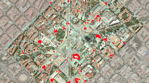
Therefore, as the main output of this project, the ConsTRACK tool was developed. The tool is based on near real-time satellite imagery that tracks every visible change and activity in a desired location and presents it in a user-friendly way, letting users track the process from a distance.
ConsTRACK’s generic track changing algorithm together with consolidated user requirements, opened more markets besides the construction one during the project lifetime. The tool provides several solutions such as the monitoring of activity in remote locations and the change tracking to analyse past events for the Waste Management, Oil and Gas, Insurance and Water markets.
More than 100 potential stakeholders have been contacted during the project lifetime, with their feedback the team was able to understand the user needs, improve the tool and redefine the service value proposition.
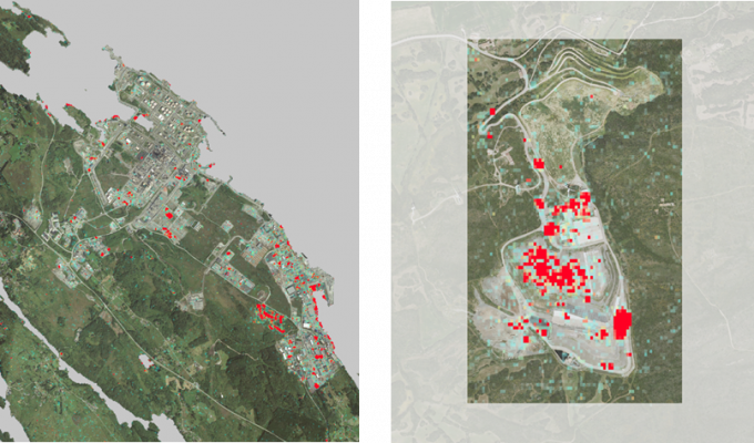
The tool can monitor from 5 ha (0.05 km2) up to 250,000 ha (2,500 km2) in each observation, detecting all changes on the selected location on a weekly basis.
Because of the use of Copernicus Sentinel-1 (radar) as the main source of information, ConsTRACK is fast and robust, with day and night worldwide coverage, even on tropical or high latitudes that are covered with clouds most of the time. Moreover, the use of open imagery allows to provide a sustainable and scalable service with competitive fares for the users. This clearly defines ConsTRACKs added value and the future expansion of ConsTRACK as a commercial product.
The way forward
While talking to potential customers and delivering the technical work, the team identified multiple important EO aspects that could enhance the results in current and future products:
- Polarimetric analysis: upgrade change severity map including polarimetric analysis (Dual-Pol) to perform a better change detection from the RADAR SAR intensity signal to classify changes
- Coherence analysis: explore the use of the RADAR SAR phase and coherence/interferometric analysis to derive permanent scatters and classify changes
- Multitemporal Sentinel-1 series analysis: detection of events on time series or SAR, with integration of AI
- Multitemporal analysis/change detection with Sentinel-2: extend the change detection methodology to solar spectrum imagery and even propose an integrated method with SAR-C (Sentinel-1) and solar spectrum (Sentinel-2) imagery
- Industrial activity detection via thermal changes with Sentinel-3/Landsat 8 (and future missions)
- Industrial activity detection via air quality changes with Sentinel- 5P (and scheduled and future missions).