Methane emissions from fossil fuel production are a major component of the anthropogenic methane emission budget. Emissions from this sector often occur as strong plumes from so-called point sources, which include infrastructure elements such as flares, compressor stations, storage tanks, or mine vents. Satellite remote sensing represents a key technology for systematic monitoring of methane emissions from such point sources around the world.
Typically, the detection of methane emissions relies on Copernicus Sentinel-5P, which provides a daily global map of methane concentration at a coarse 7×5.5 km resolution. Nonetheless, recently scientists have been exploring the use of higher resolution data to allow localising and quantifying emissions accurately besides detecting the presence of methane.
Exploiting the 2300nm spectral region
Methane presents absorption features in the 2300 nm shortwave-infrared region, and this allows methane retrievals using land-oriented high-resolution (20-30m) optical satellite missions.
The HiResCH4 project, funded under the Permanently Open Call, has been exploring potential and limitations of Sentinel-2, Landsat-9, PRISMA and EnMAP, especially focusing on:
- Consolidation of methane retrievals with hyperspectral and multispectral missions, including EnMAP, PRISMA, Sentinel-2 and Landsat
- Assessment of methane sources across large fossil fuel production areas, including oil and gas basins in Algeria and Turkmenistan and the coal mining Shanxi region in China
- Evaluation of methane retrievals from offshore sources and from the future Sentinel-2 NG mission.
Benchmarking EnMAP against PRISMA
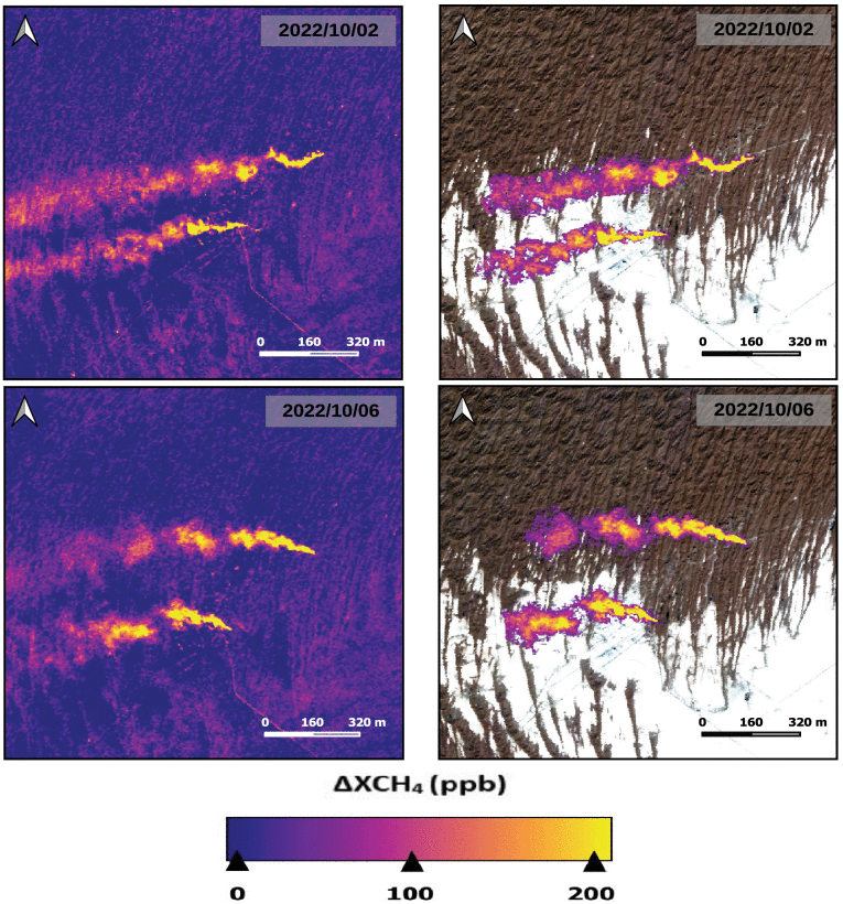
Detection and quantification of methane emissions at high spatial resolution, which allows the attribution of plumes to sources, has been successfully proved with hyperspectral PRISMA data.
The HiResCH4 project focused during its second phase on analyzing EnMAP’s performance in CH4 retrieval, comparing it with PRISMA as a benchmark.
Results, published as a peer-reviewed paper, indicate that EnMAP exhibits finer spectral resolution and higher signal-to-noise ratio (SNR) compared to PRISMA in the 2300-nm absorption window. The study demonstrates EnMAP’s potential for more precise CH4 retrieval, leading to improved detection of CH4 emissions, especially from challenging sites like landfills.
Onshore vs offshore
Multispectral missions such as Sentinel-2 offer a high spatial resolution together with a frequent global coverage, although they might have a sensitivity to methane lower than the one of hyperspectral sensors.
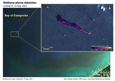
Methane detection with multispectral sensors was tested during the first phase of the project on a variety of sources, enabling large-scale surveys of individual point sources in Algeria and the Shanxi region in China, and the first satellite-based detections of methane plumes from an offshore platform in the Gulf of Mexico. The second phase of HiResCH4 was defined to extend the methods and tools developed in the first phase, especially towards detecting off-shore plumes, resulting in real plumes from active offshore sources being detected.
This project identified the value in multi-spectral instrument methane retrievals from space, and points the way to further expansion of these techniques with further enhancements required to pin-point individual sources and quantify their emission rates. In particular, the capabilities of other instruments currently in operation (GHGSat and MethaneSAT), and to be launched soon (Carbon Mapper) or in the next years (CHIME and Sentinel-2 NG), hold the promise of significantly elevating our capacity to systematically evaluate point sources across diverse sectors on a global scale.
Featured image: Zaap-C offshore platform with many other offshore platforms visible flaring in the Gulf of Mexico on a Copernicus Sentinel-2 image from 28 December 2021. Contains modified Copernicus Sentinel data (2021), processed by ESA, CC BY-SA 3.0 IGO