The loss of ice from Antarctica is one of the principal causes of contemporary sea level rise. Tracking the changes that are currently occurring across this remote and inaccessible continent requires systematic satellite monitoring programmes. From these unique observational platforms, robust long-term climate records can be developed, which help scientists to understand and to predict climate change.
In this study, an international group of researchers funded by ESA’s Scientific Exploitation of Operational Missions element investigated the potential of the Sentinel-3 radar altimeter – one of the EU Copernicus satellite missions – to monitor the Antarctic Ice Sheet. They found that the satellite is able to provide reliable measurements of the ice surface, and has the potential to contribute towards long-term ice sheet monitoring programmes.

Courtesy of: ESA/ATG Medialab
From its orbit 815 km above the Earth, Sentinel-3 was able to detect the height of the ice surface at the remote Lake Vostok test site in East Antarctica to within tens of centimetres.
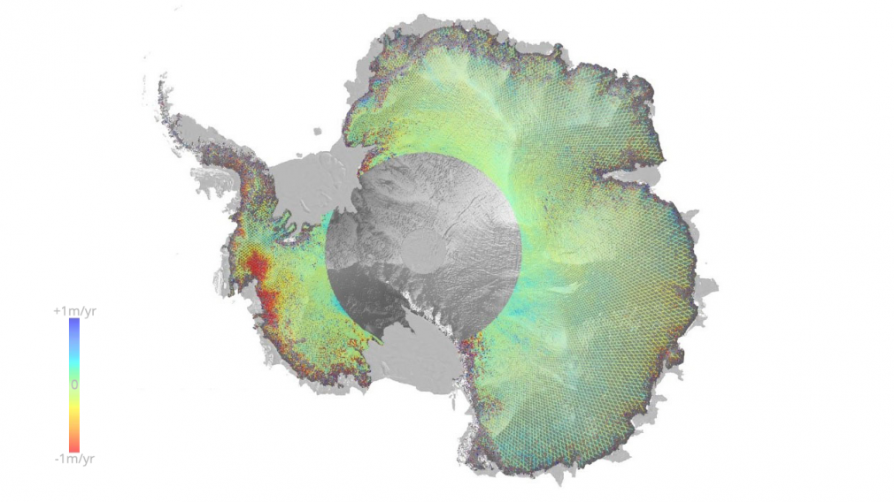
The scientists also found that Sentinel-3 could detect areas where the ice surface was rapidly lowering, thereby establishing the satellite’s credentials as a new platform to help monitor Antarctica’s contribution to sea level rise.
Sentinel-3 uses a radar technique called Delay-Doppler altimetry to make high resolution measurements of the height of the ice sheet. Determining how well Sentinel-3 functions over ice sheets is particularly important given that CryoSat-2, ESA’s dedicated polar mission, is already operating well beyond its planned lifetime.
Lead author Dr Mal McMillan, from Lancaster University and the UK Centre for Polar Observation & Modelling, said: “Although the Sentinel-3 altimeter was primarily designed to monitor the oceans, we wanted to test how well it works over ice, and to see whether it is able to detect signs of ice sheet change. Through ESA’s support of our Sentinel-3 Performance Improvement for Ice Sheets (SPICE) study, we have been able to analyse the performance of the Sentinel-3 altimeter mission for several years now. From what we can see here, with just two years’ worth of data, Sentinel-3 is going to be a very useful tool for surveying the Antarctic ice sheet.”
Dr McMillan explained: “This level of accuracy means that we can also use Sentinel-3 to track important features on the ice surface, like the fingerprint of active subglacial lakes draining and refilling beneath several kilometres of ice.”
Co-author Jérôme Benveniste of the European Space Agency summarised: “We are delighted with the early promise shown by Sentinel-3 for ice sheet monitoring, and are increasingly confident that it will be a long-term asset to climate science”.
The full results of the study are reported in: McMillan, M. et al. (2019). Sentinel-3 Delay-Doppler altimetry over Antarctica, The Cryosphere, 13, 709-722 http://doi.org/10.5194/tc-13-1-2019
Featured image : Antarctic Ice Sheet elevation change mapped by Copernicus Sentinel-3A between 2016 and 2018. Contains modified Copernicus Sentinel data (2018)/processed by CPOM/McMillan