NOVELTIS SAS (FR)
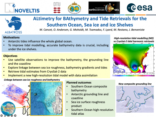
The ALBATROSS Project (ALtimetry for BAthymetry and Tide Retrievals for the Southern Ocean, Sea ice and ice Shelves) , led by NOVELTIS in collaboration with DTU, NPI and UCL, is one of the activities funded by ESA in the frame of the Polar Science Cluster, with the objective to foster collaborative research and interdisciplinary networking actions.
In this framework, the ALBATROSS ESA Project aims to improve knowledge about bathymetry and ocean tides in the Southern Ocean.The knowledge about ocean tides is at the crossroads of many scientific fields, especially in the Polar regions, as it has significant impact on ocean circulation modelling and the understanding of the coupled dynamical response of the ocean, sea ice and ice shelves system, the quality and accuracy of sea surface height and sea ice parameter estimates from satellite altimetry, or the understanding of ice-shelf dynamics, for example.Today, this knowledge is still limited by several aspects, such as the quality of bathymetry information, hydrodynamic model resolution and in situ and satellite observations availability for data assimilation and model validation.
The objectives of the project are the following:
The ALBATROSS Project was launched in May 2021 and will span over two years.
——————————————————————————————————————-
Presentation at the Living Planet Symposium (LPS22):
ALBATROSS: Improving the bathymetry and ocean tide knowledge in theSouthern Ocean with satellite observations, M. Cancet, O. Andersen,M. Tsamados, G. Moholdt, F. Lyard, M. Restano, J. Benveniste
——————————————————————————————————————-
PROJECT DOCUMENTS
PUBLICATIONS & COMMUNICATIONS
——————————————————————————————————————-
The ALBATROSS Mid-Term Review meeting was held on the 23rd of June2022. The work on the bathymetry, coastline and grounding linedatasets that will feed the hydrodynamic tidal model is almostcompleted. Hydrodynamic tidal simulations have been performed inorder to assess the accuracy of the new bathymetry datasets andprovide feedback about improved areas and regions where furtherimprovements may be needed. The exploratory work on the linkagesbetween sea ice surface roughness computed from MISR data,bathymetry features and vertical tidal excursions shows promisingresults and could be used as a complementary tool to assess therealism of some features in the bathymetry models. Finally, thetidal harmonic constituents retrieved from 10 years of CryoSat-2observations in the Southern Ocean provide an invaluable validationdatabase for the tidal model, bridging the gap between the scarcecoastal in-situ observations and the Topex/Jason conventionalaltimetry observations that are limited to 66°S and stronglyaffected by the presence of sea ice. The implementation of the newhigh-resolution tidal atlas will continue in the coming months andwill be followed by an assessment phase

ALBATROSS: Advancing Southern Ocean tide modelling with high resolution and enhanced bathymetry
Polar Science (2024)
Polar Ocean Tides—Revisited Using Cryosat-2
Remote Sensing (2023)
Mapping Arctic Sea-Ice Surface Roughness with Multi-Angle Imaging SpectroRadiometer
Remote Sensing (2022)