The Geohazards Exploitation Platform (GEP) is the outcome of an ESA initiative to implement Thematic Exploitation Platforms, i.e. advanced on-line processing environments dedicated to user communities in specific thematic areas. The GEP is looking at geological and hydrogeological hazards with a focus on terrain motion mapping. In the context of its current evolution, the GEP now provides access to a new collection of products: the Copernicus European Ground Motion Service (EGMS) Ortho Vertical (Level 3) covering the period from 2018 to 2022. The Copernicus EGMS provides valuable insights into ground movement across Europe, helping us better understand and manage risks associated with earthquakes, volcanoes, landslides, and land subsidence.
What is the EGMS ortho vertical product?
The EGMS Ortho Vertical product is a free and open historical record of terrain motion measurements delivered at high-resolution on an annual basis and across Europe. It is using data from the Copernicus Sentinel-1 mission and the Synthetic Aperture Radar Interferometry (InSAR) technique. The purely vertical displacements with millimetre precision are resampled to a 100 m grid.
The EGMS is part of the Copernicus Land Monitoring Service product portfolio, which is implemented by the European Environment Agency within the EU Copernicus programme.
Benefits of accessing EGMS data on the GEP
While there are various ways to access EGMS products, access via the GEP unlocks new possibilities, providing several key features specifically implemented to support geospatial data analysis:
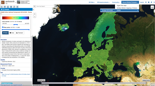
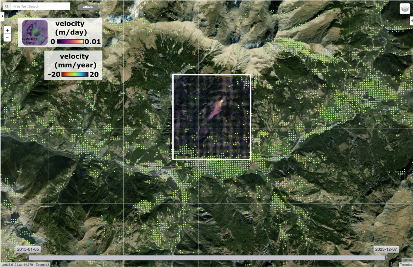
- Dynamic visualization: Users can dynamically visualize the average velocity of ground movements on a map, enhancing the understanding of spatio-temporal patterns. Measurement points are clustered automatically in space according to the visualization scale for improved readability.
- Customizable data representation: via layer selection, look-up tables and colour scale adjustments, users can tailor the data presentation to meet specific analytical needs.
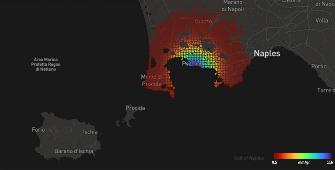
- Advanced data filtering: The viewer allows for filtering points according to velocity thresholds, facilitating focused analyses on areas of interest (see story header image).
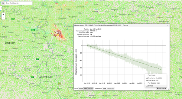
- On-the-fly time series visualization: Users can interact with the geo-browser and plot displacement time series for specific points, generate statistics for areas of interest, and visualize mean velocity and surface elevation values along geographic transects.
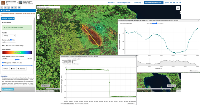
- Export of time series data: Users can export the time series of terrain motion measurements on the map over the area of interest . They can be saved in CSV and CovJSON format. Through simple auto-registration, users can also download the original tiles of the EGMS Ortho product.
The EGMS Ortho Vertical dataset can be accessed via the newly introduced Time Series Viewer offered in the Public Workspace among the GEP Ground Motion Products (see « Ground Motion Products > EGMS > Europe 2018-2022 » on the upper right menu). Registered GEP users can also download the original dataset tiles in CSV format.
Benefits of the GEP as a processing environment
Besides seamless and smart access to the EGMS Ortho Vertical product, the GEP supports ad-hoc analyses that are complementary. The on-line environment provides multi-mission EO data, including data collections for research users and commercial data that can be uploaded by the user, alongside with a suite of EO-based processing chains, both optical and radar, available on-demand in the same platform. A geoscience user is able to generate ad hoc measurements using one of these services over an EGMS annual product.
Examples of these processing chains include the P-SBAS provided by CNR IREA, SNAPPING PSI provided by the Aristotle University of Thessaloniki alongside terrain motion services using optical data (such as the GDM-OPT service of CNRS EOST).
Explore the possibilities and join the geo-hazards community
The sponsorship by ESA via the Network of Resources (NoR) has been instrumental in ensuring free access to EGMS Ortho Vertical data for the next two years.
The NoR sponsorship program aims to enhance the capability of user communities by providing tailored support for the utilization of EO based platforms such as the GEP, in particular by covering the resource consumption required for accessing data and processing them. Beyond supporting the access to Copernicus EGMS products on the GEP, the NoR can help specific users access on-demand EO services – including advanced InSAR chains – that can complement the geoinformation provided with the annual EGMS production.
For more information about how the NoR supports other projects, and to explore sponsorship opportunities, please visit the NoR page.
Researchers, industry professionals, and anyone interested in geohazards are encouraged to explore the EGMS data on the GEP and/or to submit a proposal to the NoR. Join our user community to learn more, share your findings, and contribute to a better understanding of our planet’s geohazards.
The GEP governance
The GEP platform is guided by a collaborative Governance body. This body comprises public and private organisations, with Terradue serving as the operator. Service providers including AUTH, MJaen, CNRS EOST and CNR IREA all contribute their expertise and services to the platform. ESA is supporting science and application developments related to EO data processing with expert users and with providers of service chains that are integrated in the GEP. In this respect ESA is an observer at GEP governing body meetings.
Featured image: Example of map visualization filtered according to a velocity threshold (> 0.5 mm/yr) in the area of Campi Flegrei in Italy. Data can be visualized on various background maps.