There is an increasing threat from water-related issues impacting the human population through global warming, shifts in precipitation patterns and extreme weather conditions, all leading to water stress, including natural disasters such as floods or droughts, with a risk of severe damage to the environment, property and human life. A less studied aspect of such events is their impact on human health through waterborne diseases.
The ESA-funded project Waterborne Infectious Diseases and Global Earth Observation in the Nearshore (WIDGEON) provided a perspective on the capabilities of remote sensing to build capacity and resilience against waterborne diseases under extreme weather conditions in coastal regions. The usefulness of remote sensing has previously been demonstrated in the mapping of waterborne diseases such as cholera, but it remains unexplored as a global public health tool, though Earth Observation data from satellites are increasingly available at the global scale in real time, with free, open, and timely access. This resource enhances the potential for developing cost-effective methods to build a capacity to monitor risks to human health from waterborne diseases.
A coastal location highly vulnerable to water-associated diseases
The Vembanad-Kol wetland system, in the southwest of the Indian Kerala region, was selected for an in-depth analysis of how remote sensing could contribute to building a community that is resilient to climate change and extreme weather events. Waterborne diseases such as cholera are endemic in the region, and WIDGEON in situ observations show high levels of faecal contamination in the waters of Lake Vembanad and in the near-shore waters. The region is compact, facilitating exploration of the human dimension, and it allows engagement with the local population to make them part of the solution.
Mapping of flooded areas
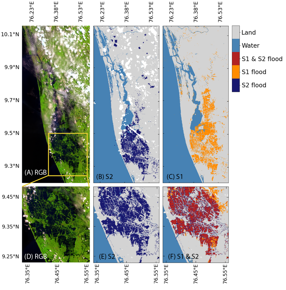
In August 2018, Kerala experienced an extremely heavy monsoon season, which caused once-in-a-century floods that led to nearly 500 deaths and the displacement of over a million people.
In a recent study, scientists funded through the WIDGEON project examined the use of existing algorithms to map flooded areas in the Lake Vembanad region using the spectral reflectances of the green, red and near-infrared bands from the multi-spectral sensor on board Sentinel-2. Although the multi-spectral imaging sensor has no cloud-penetrating capability, the study showed that existing water index algorithms applied to Sentinel-2 could complement commonly used synthetic-aperture-radar-based techniques to improve temporal coverage from 12 to 5 days.
They also showed that local knowledge of paddy cultivation practices could be used to map the management of water levels in paddy fields and distinguish inundated fields from accidental flooding to improve the usefulness of flood maps in the study region. Flood maps have the potential to become part of a solution package based on multi-spectral visible remote sensing, along with maps of water quality and risk of human pathogens in the environment, providing additional fundamental services during natural disasters.
Understanding faecal contamination
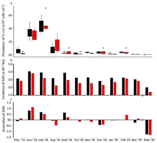
Extreme weather incidents, such as heavy rains and floods, can introduce pathogens and their vectors into natural water bodies as well as influence their survival, reproduction and transmission. A year-long study was conducted in the Vembanad Lake region to understand the influence of heavy rains associated with the southwest monsoon as well as the 2018 floods on the distribution of Escherichia coli in lake waters and its relation to the incidence of acute diarrheal disease (ADD). E. coli was prevalent in the lake throughout the study period, with highest abundance of E. coli and incidence of acute diarrheal disease recorded during the early phase of the southwest monsoon (June-July), prior to the floods.
Multiple antibiotic resistance was recorded among 50% of E. coli isolates, confirming an anthropogenic influence on the faecal contamination of the lake and adding to the urgency to control contamination. The research has helped to put in place the first, broad-brush budget of the sources of E. coli pollution in Vembanad Lake, and refining this budget and tracking changes call for continuous monitoring of the water bodies for a longer time period, using both in situ and remote sensing observations. It also pointed to a need for revamping the sewage treatment engineering and city planning to avoid the mixing of septic sewage with natural waters during extreme climate events such as floods, or even during the natural monsoon cycles of heavy rains. As our understanding of the ecosystem improves, risk maps to alert the local population against the threats from waterborne diseases can be developed and improved to help plan remedial actions.
Training the next generation of EO scientists
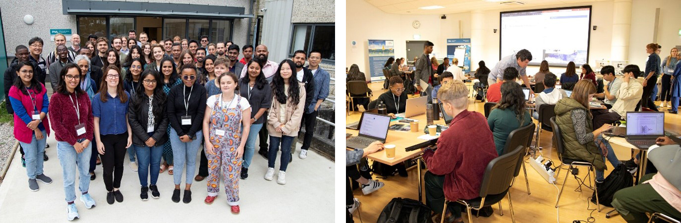
Building capacity was an important part of the WIDGEON project, including training of students and early career scientists in Earth Observation. Together with the Trevor Platt Science Foundation, and other like-minded international organisations, ESA and scientists from the WIDGEON project delivered an online and in-person training course on Satellite-based tools for investigating aquatic ecosystems that covered a variety of topics, including human health in relation to the aquatic environment. The online training course reached between 200-400 participants each week and the recorded webinars are available online with ~3,500 views to date. An in-person training course took place over 2 days at Plymouth Marine Laboratory, UK, with one session on water quality in relation to human health. A group of 40 students successfully completed the in-person training course and presented their own project ideas at the end of the course. Following the in-person training course, the TREVOR symposium was organised over 3 days with 140 participants from 38 different countries worldwide attending. Oral and poster presentations related to human health took place throughout the symposium and two network sessions on capacity building and UN’s Sustainable Development Goals were organised. Both the training and the symposium were highly successful events, and overwhelmingly positive responses were received.
Way forward
Results from the WIDGEON project to date have improved the understanding of the spread of water-associated diseases in a coastal region that is vulnerable to flooding, storm surges and sea-level rise associated with climate change. Remote sensing has the potential to become part of a solution package in combination with other digital technologies to monitor public health. As part of the WIDGEON project, a smartphone application is being developed for citizens to report and access information on sanitation conditions, which will support building further capacity and resilience against waterborne diseases in the Lake Vembanad region.
More activities are being carried out at ESA on EO for Health.
Upcoming, next week on 15-16 January, an EO4Health User Forum 2024 is going to take place online to:
- Identify the current main challenges related to Global Health and Earth Observation at large
- Discuss with scientists, policy makers and industry the most pressing needs and information requirements
- Provide users and stakeholders with Earth Observation data, resources and capabilities.
You are welcome to join!
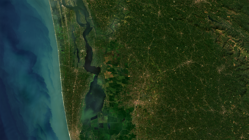
Featured image: Lake Vembanad, Copernicus Sentinel-2 RGB composite image. Contains modified Copernicus Sentinel data (2019), processed by the Widgeon project team, CC BY-SA 3.0 IGO