Precise geocoding/orthorectification/co-registration of EO images are pre-requisites for most further data use and applications. These operations require precise, high-quality Ground Control Points (GCPs).
The Sentinel for 3D Ground Control Point (Sen3GCP) project, funded via the EO science for society Permanently Open Call mechanism, has been developing a GCPs hub, a dedicated service with several functionalities.
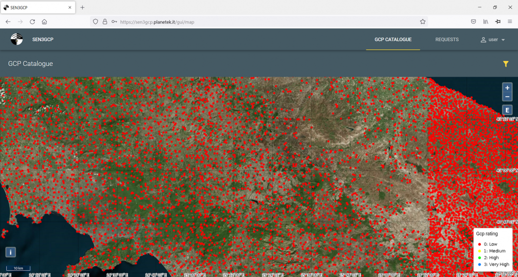
Worldwide GCPs repository
The system gives access to a global coverage GCPs database, also including inaccessible areas of the Earth and, whenever possible, different versions of the same GCP (with varying time range and quality).
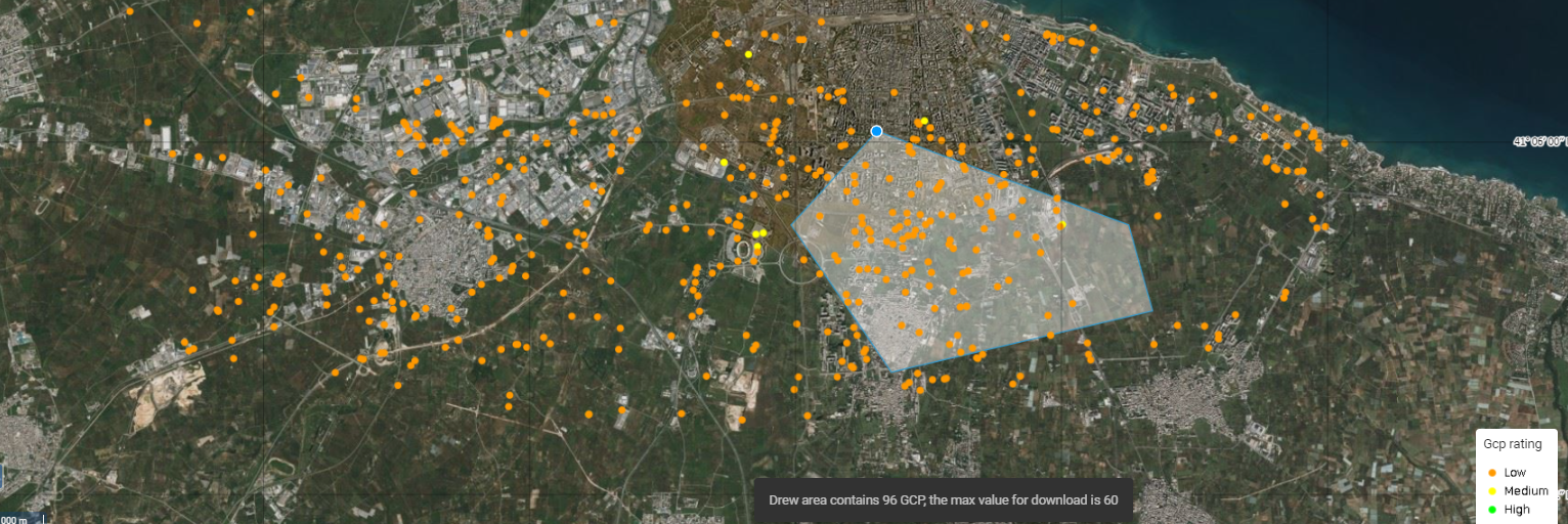
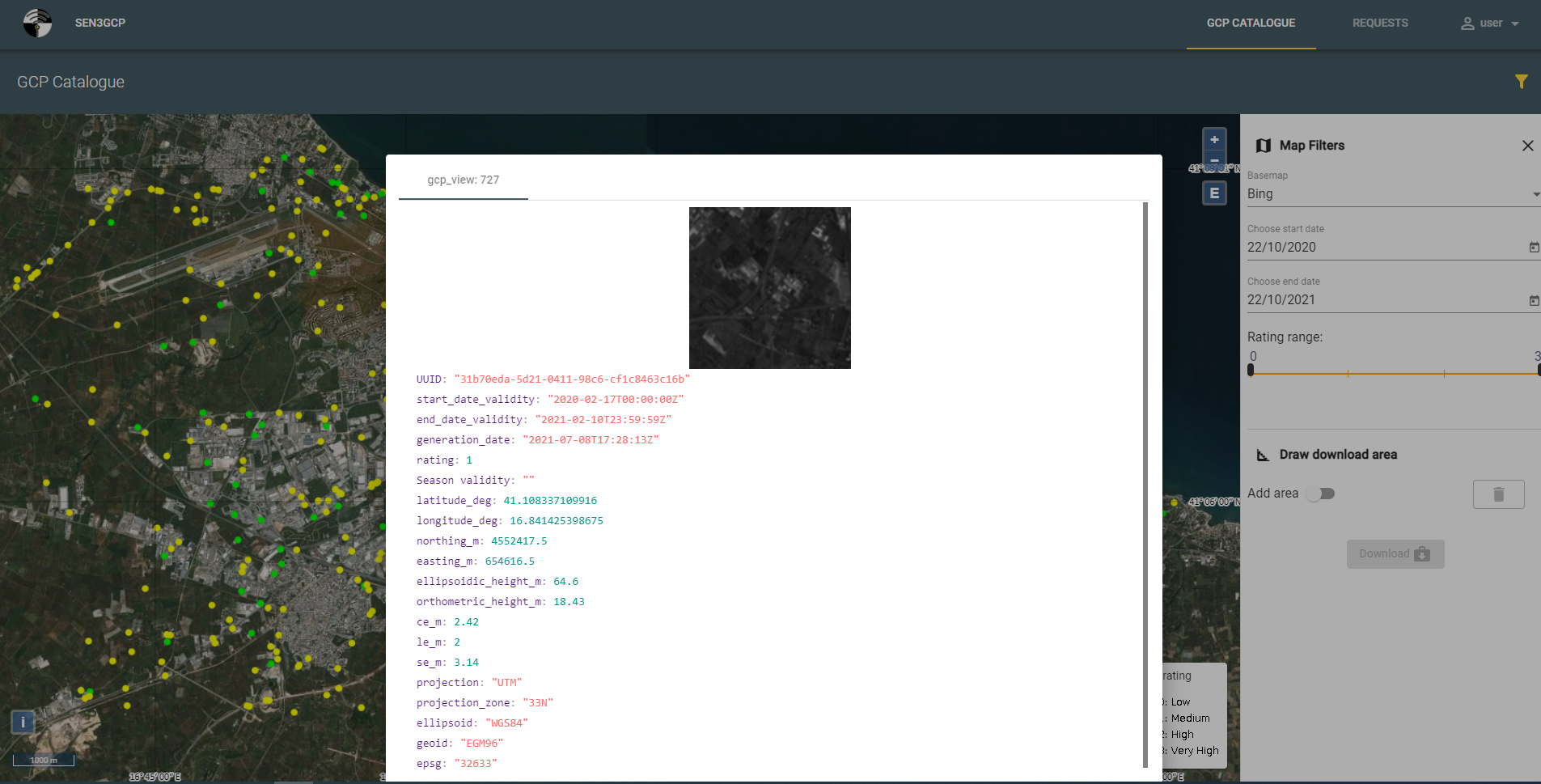
An easy-to-use interface enables requesting, visualizing, and downloading the data, which can also be accessed via API.
Authenticated users will land on the GCP catalogue immediately after login, and be allowed to select an area of interest and inspect GCP data and metadata before further use or download.
Generation of new GPCs from SAR data
The system includes a functionality to extract new GCPs from SAR data takes.
The algorithm is primarily built on C-band Copernicus Sentinel-1 constellation and focused on images acquired in TOPS IW mode (the EW mode is not of interest because of the coarse spatial resolution). However, it can also be applied to S1 stripmap data, as well as stripmap and spotlight data acquired by other high resolution X-band SAR missions, such as TerraSAR-X, TanDEM-X and COSMO SkyMed [1].
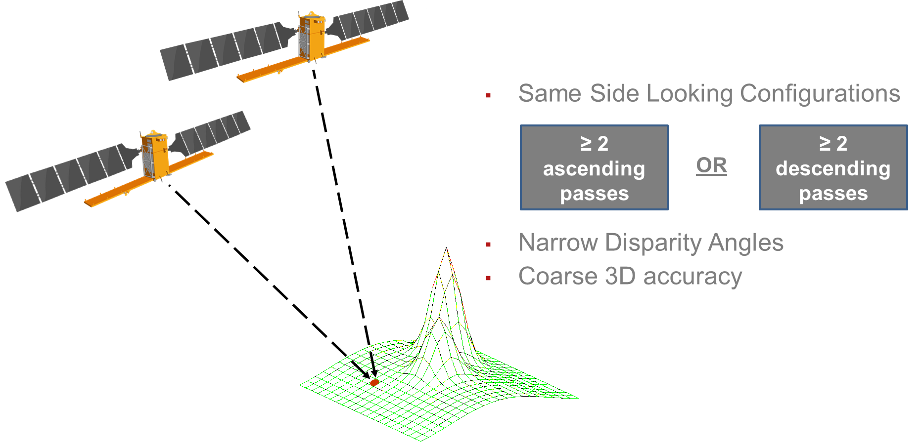
The algorithm uses Level-1 (SLC) co-polarized products as input and exploits various combinations of different acquisition geometries in order to allow spatial triangulation and retrieval of 3D info for candidate GCPs.
A first option is the Opposite Side Looking (OSL) configuration, using a combination of ascending and descending passes.

A second option is the Same Side Looking (SSL) configuration, using a combination of identical passes but different orbital tracks and different incidence angles.
Alongside high-precision GCPs using SAR data, standard and enhanced optical GCPs with increasing levels of accuracy will be offered to users.
Optical/SAR images co-registration
In order for the 3D info derived from SAR data to be associated to an optical chip (small sub-image centred at the GCP), registration of the SAR and optical datasets is mandatory.
Hence such registration function is also provided by the system, and can be applied to any acquisition times, sensors, and viewpoints combinations.
Image registration techniques roughly fall in two categories: feature- and intensity-based. Feature-based techniques depend upon detecting and matching landmark features within the images, while in intensity-based techniques images are registered based on a relation between pixel intensity values of the two images.
Considering the difficulties of extracting common features (either automatically or manually) for SAR and optical image pairs, the available registration functionality makes use of intensity-based registration techniques (using the SI-SIFT – modified version of SAR-SIFT – algorithm). [2]
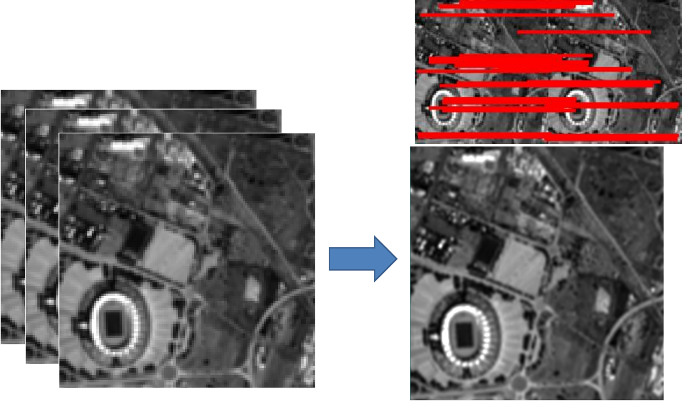
Optical images orthorectification and co-registration
Orthorectifying multi-spectral optical images is a core functionality offered by the system. GCPs are used either for refining an attached Rational Polynomial Coefficients (RPC) model or generating an RPC model for L1 images without geocoding model.
The functionality performs an automatic matching between the optical image and the GCP optical chip. This step is executed using a feature and frequency algorithm based on Fourier-Mellin Transform, and can also use a modified version of SAR-SIFT (SI-SIFT) to estimate residual errors between GCPs and matched point over the optical image. The matching permit results refine the image’s geocoding model and provide an affine model for the final warping step.
The same approach is used to build an RPC model for a non-geocoded image and for registration of already orthorectified images.
Geolocation accuracy check and improvement
Some GCPs, not used in the processing, can be exploited for an automatic assessment of the final geolocation accuracy.
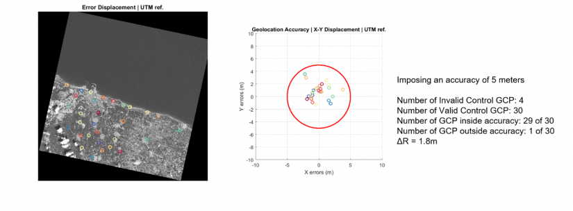
The GCPs, when applied to already orthorectified images, allow for an accuracy evaluation and improvement process which generates a new image with higher geolocation quality.
How to access
These services, deployed in the cloud, will be accessible to anyone interested – as from the second half of 2022 – through a dedicated portal within the services platform Rheticus®, but also through M2M Rest API.
Access will be granted through user registration, but they might possibly be available within the NOR framework.
The GCPs hub will also supply the Italian Space Agency with standard quality GCP products throughout 2022, in order to enable the PRISMA mission reach a geolocation accuracy of 15 metres for Level 2 products.
1 [Nitti et al., 2016] D. O. Nitti, A. Morea, R. Nutricato, M. T. Chiaradia, C. La Mantia, L. Agrimano, S. Samarelli, “Automatic GCP extraction with high resolution COSMO-SkyMed products”, Proc. SPIE 10003, SAR Image Analysis, Modeling, and Techniques XVI, 1000302 (October 18, 2016), 12 pages; ISBN:978-1-5106-0411-7. ISSN: 0277-786X. doi:10.1117/12.2241281
2 [Nut.SPIE2016] R. Nutricato, A. Morea, D. O. Nitti, C. La Mantia, L. Agrimano, S. Samarelli, M. T. Chiaradia, “Automatic SAR/optical cross-matching for GCP monograph generation”, Proc. SPIE 10003, SAR Image Analysis, Modeling, and Techniques XVI, 1000303 (October 18, 2016), 8 pages; Scopus: 2-s2.0-85010868614. WOS:000391442000002. ISBN:978-1-5106-0411-7. ISSN: 0277-786X. doi:10.1117/12.2241284