Historically, the Common Agricultural Policy (CAP) has represented the biggest share of the EU budget. From more than 70 percent of finances in the 1980s to about 40 percent, the CAP provides farmers with direct payments to make their businesses more profitable, reduce risks associated with weather and guarantee food supply chains across the continent.
Subject to support as well as criticism, the CAP is now undergoing a reform to be applied in the 2023-2027 period. Such reform is aiming at better integrating EU environmental and climate legislation and contribute to the targets of the Farm to Fork and biodiversity strategies.
Among the most important changes, the CAP introduces a new way of working: each member state will design a strategic plan outlining how it intends to spend the CAP funds taking into account national needs and characteristics.
EU countries execute payments to farmers through national or regional paying agencies. A rigorous system of checks ensures that funds are delivered only to the intended beneficiaries and in the correct amounts. The EU also mandates the use of the single integrated administration and control system (IACS), including the land parcel identification system (LPIS), to check claims and track payments.
Challenges and EO data potential
Most of the EU countries are using traditional CAP subsidies control practices based on resource-consuming OTSC (on the site checks).
According to the Commission and CAP stakeholders, Copernicus Sentinel data and other technologies for monitoring area aid have significant potential benefits for farmers, administrations and the environment.
Within its April 2020 Special Report, the European Court of Auditors analyses the use of Copernicus data in the CAP context to date and recommends that “the Commission provide incentives to Member States to use checks by monitoring in the post 2020 CAP as a key control system. We further recommend that the Commission make better use of new technologies for monitoring environmental and climate requirements.”
The following figure shows which use of EO data has been done in 2019. It does not show though how use level and type varies across EU countries, depending on climatic and land use pattern characteristics as well as specific national regulations and administrative procedures.
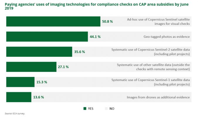
Even though several paying agencies have been involved in research projects or even systematic use of Copernicus data services for CAP checks by monitoring, operational services covering a whole country are not easy to find yet.
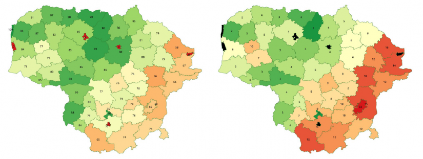
The case of Lithuania
Taking advantage of a cluster-based, ready to become a cloud-based, modular satellite imagery processing and big data analysis engine with an artificial intelligence sub-system, an operational service contract has been recently signed by the Lithuanian National Paying Agency (NPA) and the company Geomatrix UAB.
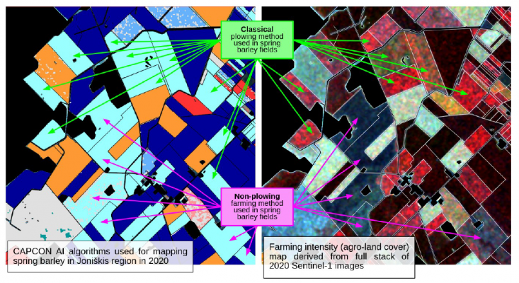
Thanks to projects funded by the ESA PECS (Plan for European Cooperating States) programme, the small company has been developing, since 2015, SAGRIS (Sentinels-based AGRiculture Information Service Component) – a complex back-end service for satellite data pre-processing, per-parcel statistical sampling, and big data analysis – and its CAPCON evolution. The CAPCON service is providing CAP subsidies control based on assessment of dense time-series of statistical measurements, which are processed with machine learning algorithms to confirm or decline the per-parcel declarations within 10-day periods during the farming season.
Intense cloud cover in the Baltic Sea region hampers an effective use of Sentinel-2 data, hence the Lithuanian company focused on Sentinel-1 polarimetric SAR data for detection of the main crops, farming activities and grass mowing events.
Based on standard Python libraries and (wherever feasible) ported on binary dockers, deployed on a scalable parallel processing cluster, CAPCON implements a complex, but seamless work-flow of satellite data pre-processing and temporal analysis, per-parcel statistical sampling and machine learning modules.
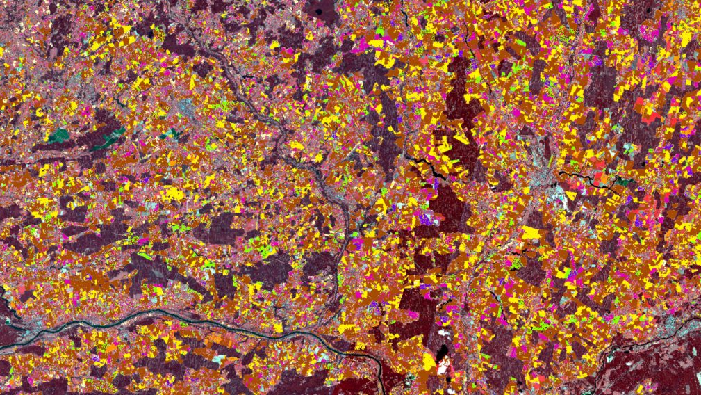
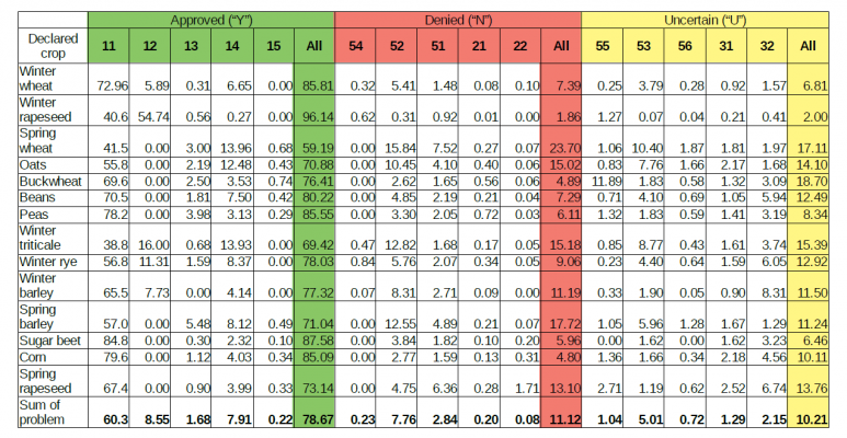
It includes algorithms for the main land cover (ineligible for support areas, grasslands, arable land, ruderal vegetation), dominating crop types (winter rape, winter wheat, winter rye, winter barley, winter triticale, spring wheat, spring rape, spring barley, spring triticale, buckwheat, peas, beans, corn, sugar beet), and agricultural practices (permanent and cultivated grasslands, black and green fallows). Land cover algorithms for fields larger than 0.5 ha were validated by the National paying Agency using standard JRC methodology and were confirmed to have reached the accuracy of about 94% during the testing phase.
Importance of partnership for the future
After pilot testing during 2019-2020 farming seasons, the CAPCON service was successfully integrated with the information system of the National Paying Agency of Lithuania and a service contract is now in place. 2021 was the first season of operational use of CAPCON service, and it was successfully completed in early August after validation and acceptance of all service results by the National Paying Agency.
This happened thanks to Geomatrix UAB and iTree Lietuva – the framework contractor for development and maintenance of the National Paying Agency information system – implementing a shared business model based on exclusive responsibilities related to particular CAP subsidies control service elements. Such partnership enabled tackling obstacles related to the paying agency IT infrastructure, internal processes and organisational structure as well as expertise characteristics.
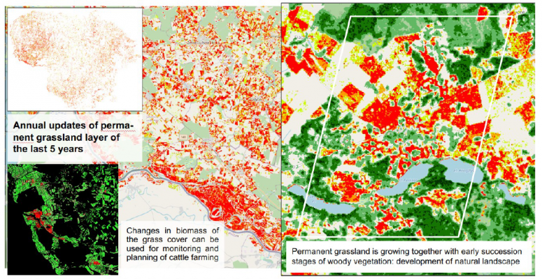
Keeping an eye at the evolving CAP and its related new performance indicators that will have to better take into account environment, climate and biodiversity, the CAPCON project already started exploring a number of additional innovative SAR-based thematic land cover/use maps (e.g. farming intensity, woody vegetation cover, permanent grassland, soil moisture).
Let’s see how these preliminary results will lead to new services and new partnerships now that Lithuania is a new ESA associate member state fully participating to the Future EO programme!