KP Labs Sp. z o.o. (PL)
Farmers and field owners need information about the soil parameters to optimize the fertilization process. This may ultimately lead to selecting a better mix of fertilizers, and to reducing the overall amount of them. The current approach toward quantifying the soil parameters (e.g., macroelements) is very user-dependent, laborious, time-consuming, vastly manual – we have to gather and mix soil samples in the field and pass them to the lab for further chemical analysis. Also, this process does not allow us to accurately capture the information concerning the macroelements, and the number of sampling points in the field is commonly limited.
KP Labs and QZ Solutions intend to use the Intuition-1 satellite to remotely detect soil parameters (specifically: potassium – K2O, phosphate – P2O5, magnesium – Mg and pH) using on-board machine learning techniques employed to analyze the acquired hyperspectral data. Hyperspectral data captures very detailed information about the observed area; however, its volume makes the data acquisition and transfer back to Earth very costly and time expensive (due to the data transmission constraints). Hence, the whole process of detecting the soil parameters will be automated on-board the Intuition-1 satellite. To make the process efficient for large-scale imaging, additional optimizations in the on-board pre-processing chain are foreseen, including filtering of too cloudy scenes based on L0 data, so heavy processing to L1 data will be avoided. Another important pre-processing step assumes determination of the bare soil area, so the soil analysis algorithms can be used only in the right context focusing on the regions of interest.
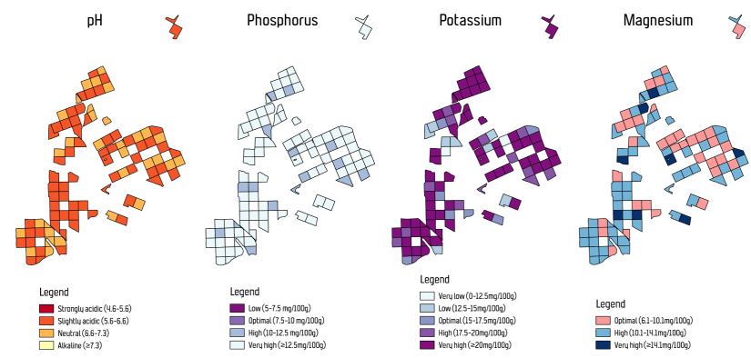
Soil parameters maps
Website: https://platform.ai4eo.eu/seeing-beyond-the-visible
A Multibranch Convolutional Neural Network for Hyperspectral Unmixing
IEE Geoscience and Remote Sensing Letters (2022)
Graph Neural Networks Extract High-Resolution Cultivated Land Maps From Sentinel-2 Image Series
IEE Geoscience and Remote Sensing Letters (2022)
Benchmarking Deep Learning for On-Board Space Applications
Remote Sensing (2021)
Deep Ensembles for Hyperspectral Image Data Classification and Unmixing
Remote Sensing (2021)