The DeepExtremes project has been awarded the regional SaxFDM Open Data Award 2025 in recognition of its outstanding approach to research data management and its strong commitment to open science. The award is presented by SaxFDM, the Saxon Research Data Management Initiative, and honors projects that exemplify best practices in making research data open, FAIR (Findable, Accessible, Interoperable, Reusable), and sustainably reusable across disciplines.
The SaxFDM Open Data Award highlights exemplary data infrastructures, transparent workflows, and long-term data stewardship strategies that enable reuse beyond the original research objectives. By recognizing DeepExtremes, the award underscores the growing importance of high-quality, openly accessible datasets for addressing complex environmental and climate-related challenges.
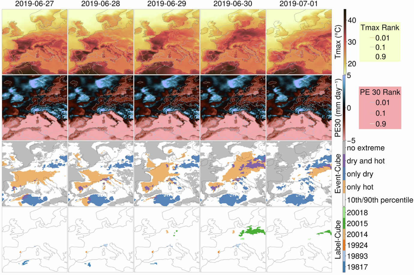
DeepExtremes is a global research activity and database dedicated to the systematic mapping of compound heatwave and drought extremes, with a particular focus on persistent natural vegetation systems. The database consists of more than 40,000 globally distributed small data cubes (so-called minicubes), each covering a spatial extent of 2.5 × 2.5 km. This structure enables scalable analyses while preserving local detail and contextual information.
Each minicube integrates multiple, harmonized data sources, including:
- Sentinel-2 Level-2A satellite imagery,
- ERA5-Land climate variables and derived extreme event information covering the period from 2016 to 2022, and
- ancillary land cover and topographic data.
Together, these components provide a rich, multi-dimensional foundation for studying climate extremes, vegetation responses, and their spatial and temporal interactions.
All DeepExtremes datacubes are openly available through EarthCODE, the ESA Open Science data infrastructure, ensuring long-term accessibility and enabling reuse by the wider scientific community. More details on the dataset may also be found within the open access data descriptor published on Nature Scientific Data in January 2025.
The SaxFDM Open Data Award 2025 recognizes not only the scientific value of the DeepExtremes database, but also its role as a model for transparent, reproducible, and collaborative climate research.
Ji, C., Fincke, T., Benson, V. et al. DeepExtremeCubes: Earth system spatio-temporal data for assessing compound heatwave and drought impacts. Sci Data 12, 149 (2025). https://doi.org/10.1038/s41597-025-04447-5