TU DELFT (NL)
Satellite observations play a crucial role due to its global and relatively uniform coverage and accuracy. Gravity data from ESA’s GOCE satellite mission provided key information in properly constraining the Earth’s density distribution, as in combination with high resolution seismological data, used in the construction of the WINTERC-G lithosphere model, which was produced in the frames of ESA’s 3D Earth project. This is a major step in the Solid Earth science community. With the upcoming ESA’s Next Generation Gravity mission (NGGM), new advances are expected in deciphering the links between the dynamic forces in the Earth’s deep interior and the processes observed at the surface of the Earth, and in high resolution spatio-temporal imaging of the crust.
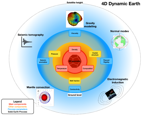
ESA’s 4D Dynamic Earth project (https://4ddynamicearth.tudelft.nl/) involves a multi-disciplinary team that looks at how we can better map, predict and understand Earth’s interior engine. During the 4D Dynamic Earth project, different sensitivity studies are performed to understand the applicability of current ground and satellite datasets available to study the dynamical behaviour of the solid Earth, particularly the complete mantle. In the frames of ESA’s predecessor 3D Earth project, the WINTERC-G model of Earth’s lithosphere was produced that complies with satellite and ground data. Now, the project team continues to go deeper and study the interactions between the core, mantle, and lithosphere in order to better predict the processes on the surface.
Of particular societal relevance is the monitoring of geohazards associated with the dynamics of subduction zones, where the most devastating earthquakes occur, and volcanoes are frequent. The evolution of these zones can only be understood in bridging different geological timescales and by joining studies on the tectonic setting and their dynamics, e.g. the new compilation of slab geometries by SLAB2.0 can be used to develop the static 3D Earth model into a dynamic 4D Earth model. Satellite data would especially be of benefit for dynamic studies in regions where active seismic networks are sparse, e.g. the Polar Regions and parts of the Pacifics.
A 4D Earth dynamic model must include a link to the deep mantle, utilizing and extending the approach developed in the 3DEarth project into a global study to address processes like dynamic topography and mantle dynamics. At global scales, model predictions of dynamic topography differ from estimates of residual topography by up to a factor of two, suggesting a lack of understanding of the relevant physical parameters, most importantly density and viscosity. Density is important both for isostasy and as the driver of dynamics. Viscosity controls the rates of the dynamical response, both for mantle dynamics but also for shorter-lived processes such as post-seismic relaxation of or glacial isostatic adjustment (related to uplift rates and impacts on ice sheet dynamics and sea level change). Constraining density and viscosity heterogeneity in the mantle, and their impact on dynamics, should be one of the fundamental goals of a new 4D Earth dynamic model.
A 4D Earth dynamic model will allow the estimation of dynamic topography from the best resolved 3D Earth structure and, therefore, help in quantifying predictions of changing surface uplift and subsidence over time. These estimates are relevant to understand the vertical movement of sedimentary basins and the drainage pattern of river systems, among other relevant tectonic processes. Uplift and subsidence history thus exert an important influence on the positioning of mineral and energy resources and contribute to the lithospheric stress field. Quantifying present-day uplift and subsidence has been identified as one of the most important outcomes of mantle flow (mass transport) models.
Related to the viscosity structure, and thus mantle dynamics, is the role of minor volatiles that may result from heterogeneity in the mantle’s tectonic and/or melting history. The current 3D Earth upper mantle conductivity model (down to 400 km depth) does not fully exploit the potential of satellite magnetic data: the magnetic Sq variation, diurnal tidal magnetic field and magnetospheric magnetic field are mostly sensitive to the conductivity variations in the 300-1200 km depth range. In order to probe the lower mantle electrical conductivity, secular magnetic variations coming from the core and observed on the Earth’s surface can be also used. Inverting satellite magnetic data to model temperature, iron content and water within the transition zone and lower mantle will allow us to properly characterize the viscosity distribution within a new 4D Earth dynamic model.
ESA GOCE and Swarm Earth Explorer satellites have been essential in revealing the secrets of our Solid Earth. Deep probing techniques, such as gravity and magnetism, help us understand the dynamic processes shaping Earth. The project will utilize the results and produce a roadmap towards a consistent whole-Earth mantle to incorporates ground and satellite data in a state-of-the-art modelling approach.

Hydrous Regions of the Mantle Transition Zone Lie Beneath Areas of Continental Intraplate Volcanism
Geochemistry, Geophysics, Geosystems (2025)
Hydrous Regions of the Mantle Transition Zone Lie Beneath Areas of Continental Intraplate Volcanism
Geochemistry, Geophysics, Geosystems (2025)
Azimuthally anisotropic Rayleigh-wave phase-velocity maps of Europe
Tectonophysics (2025)
Azimuthally anisotropic Rayleigh-wave phase-velocity maps of Europe
Tectonophysics (2025)
Bulletin of the Seismological Society of America, “Modern Seismic Tomography” Special Section (2024)
Earth-Science Reviews (2024)
Geochemistry, Geophysics, Geosystems (2024)