
A previously unknown subglacial lake beneath the Flade Isblink Ice Cap in Northeast Greenland has been discovered using EO data. The lake acts as a temporary underground reservoir, storing a substantial fraction of meltwater generated at the ice surface and delaying its release towards downstream ecosystems.
The study, an outcome of the ESA ARCTEX project and Living Planet Fellowship research, combines satellite observations and climate modelling to provide new insights into the hidden hydrological processes occurring beneath glaciers and ice caps.
The findings improve understanding of how climate-driven changes in meltwater production may affect Arctic freshwater systems.
A hidden reservoir beneath the ice
Subglacial lakes are bodies of water trapped beneath glaciers, ice caps, and ice sheets. They play an important role in the movement of meltwater through the cryosphere, temporarily storing water before releasing it into rivers, lakes, or the ocean.
While hundreds of subglacial lakes have been identified beneath Antarctica, fewer than 100 have been documented in Greenland. Most Greenland subglacial lakes have been observed only sporadically, making the discovery of a lake with a regular annual filling and drainage cycle particularly significant.
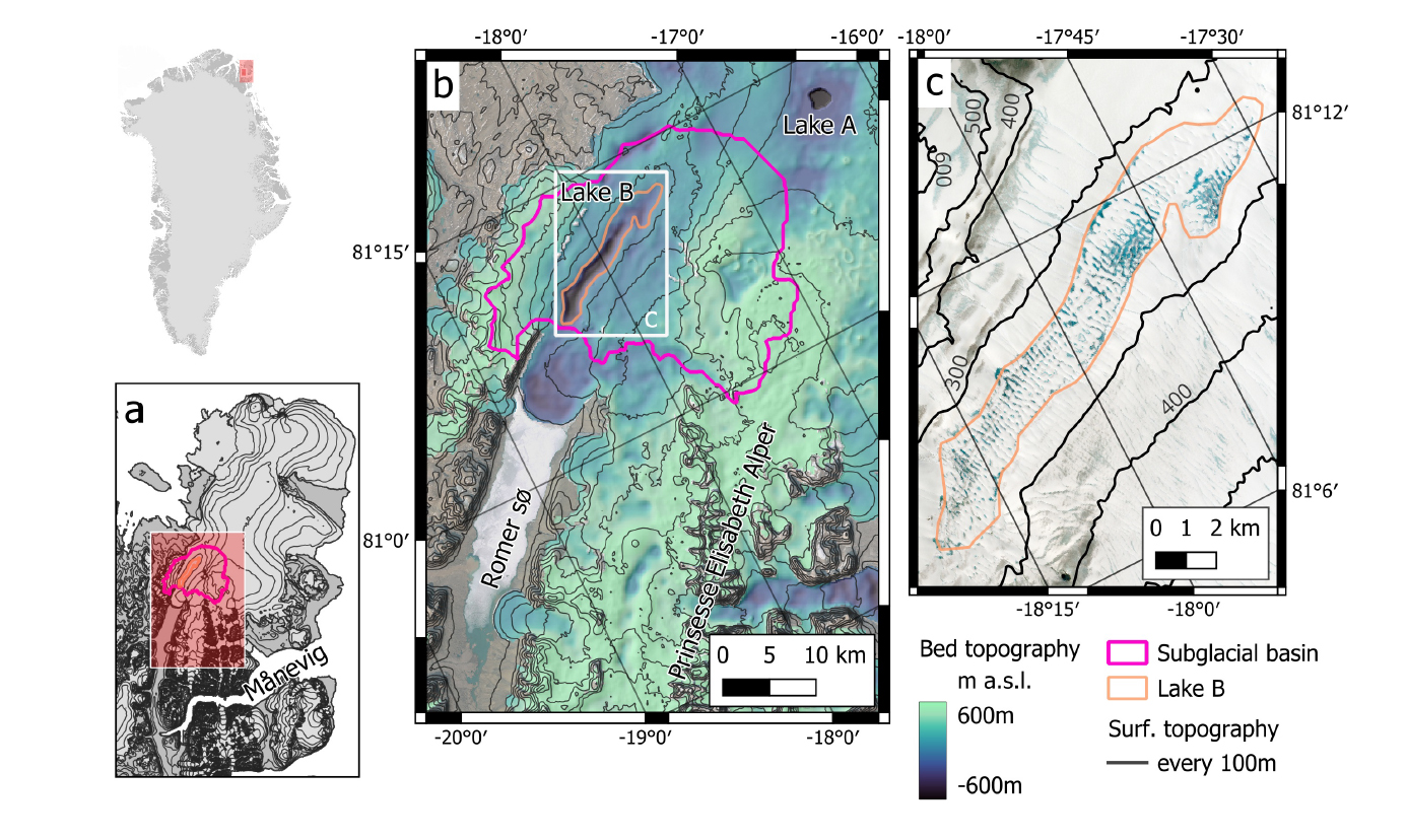
The newly identified lake, referred to as Lake B, is located beneath the western sector of the Flade Isblink Ice Cap, the largest independent ice cap in Greenland. The area is characterised at the surface by a broad depression in the ice, where meltwater ponds and streams form during summer.
Beneath this apparently quiet landscape lies a deep bedrock depression reaching around 600 metres below sea level. This topographic feature allows meltwater to accumulate beneath the ice rather than immediately flowing towards the ice margin.
Combining multiple EO datasets to observe an invisible process
Because subglacial lakes cannot be directly observed from space, researchers used a combination of satellite measurements to detect changes occurring at the ice surface.
The study integrated:
- ICESat-2 laser altimetry to measures changes in ice surface elevation with high precision;
- Sentinel-1 Double-Difference SAR interferometry to detect subtle surface movements associated with water accumulation and drainage beneath the ice;
- ArcticDEM elevation models to reconstruct surface changes over time;
- A regional climate model to estimate meltwater production in the lake’s catchment area.
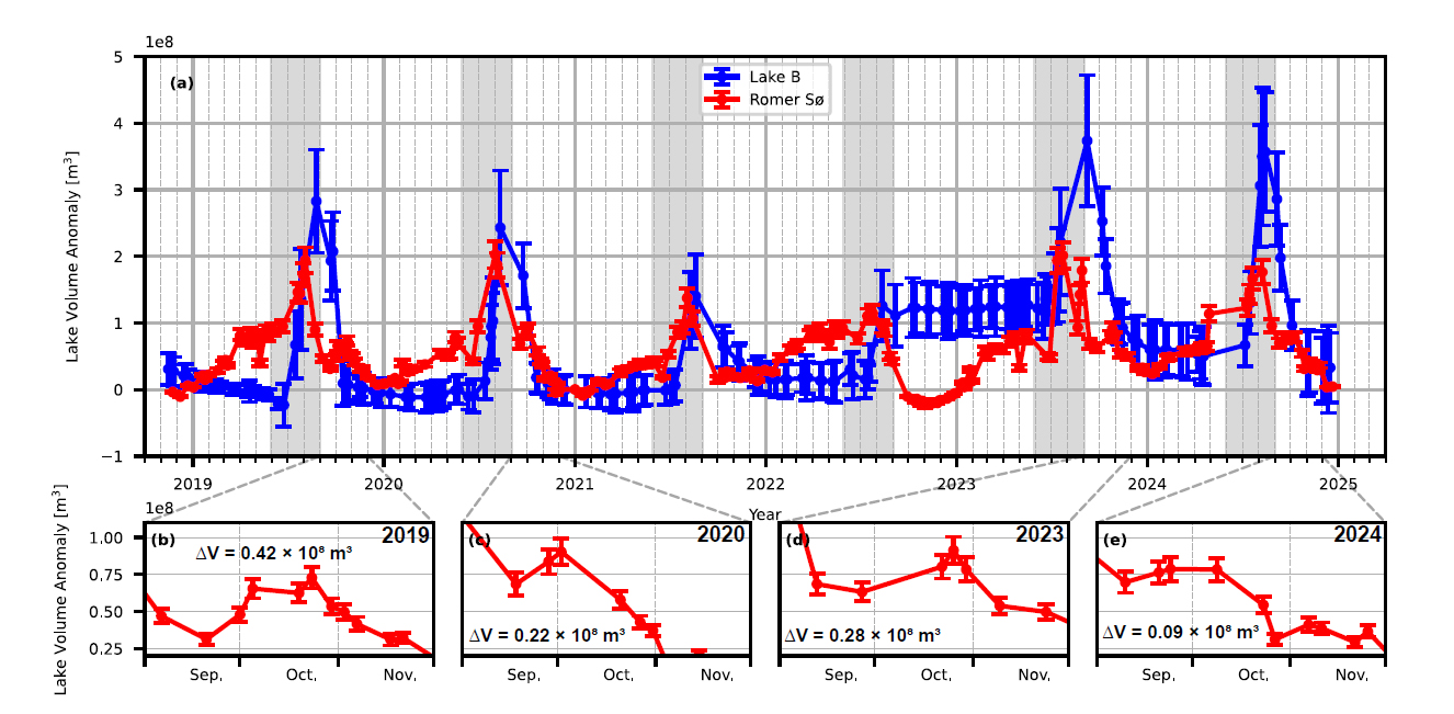
By analysing observations collected between October 2018 and December 2024, researchers identified a recurring pattern: the ice surface above Lake B rises during the melt season as water accumulates beneath the ice, then rapidly lowers in early autumn as the stored water drains away.
During peak filling, the surface above the lake was lifted by up to approximately 10 metres. Drainage events lowered the surface at rates of up to 34 centimetres per day. This occurred in all years of the observation period except 2022, which had the lowest surface melt rates, suggesting that a minimum water-input threshold is required to initiate lake drainage.
A natural storage system for Greenland’s meltwater
The observations indicate that Lake B can store up to 0.37 ± 0.11 billion cubic metres of water, equivalent to 63 ± 23% of the yearly runoff generated across its catchment area.
Rather than flowing immediately towards the ice margin, meltwater can therefore remain trapped beneath the ice for several months. In most years, drainage from the lake occurs in September and October, creating a 2–3 months delay between maximum surface melting and downstream freshwater discharge.
This discovery challenges a common assumption used in many ice-sheet and climate models: that meltwater generated at the surface rapidly reaches the ocean or proglacial environments. The study shows that subglacial storage processes can significantly modify both the timing and magnitude of freshwater release.
Connecting hidden ice processes with downstream ecosystems
The researchers also investigated whether Lake B influences the nearby proglacial lake Romer Sø, the largest ice-marginal lake in Greenland.
Satellite measurements from ICESat-2 revealed increases in Romer Sø’s water volume occurring with 2-3 months delay after peak-surface meltwater production, shortly after Lake B drainage events. This suggests that water released from beneath the ice contributes to changes in downstream lake conditions.
Such delay may affect:
- downstream hydrology and ecosystems;
- the timing of freshwater input to lakes and fjords with effects for stratification;
- glacier-fjord exchange;
- primary production.
As Arctic warming continues to alter melt patterns, integrating subglacial processes into hydrological and climate models will be essential for improving predictions of future freshwater fluxes from Greenland.
Kruse, M.A., Karlsson, N.B., How, P. et al. Previously undocumented subglacial lake beneath Flade Isblink stores most of catchment runoff and delays its release. Sci Rep 16, 30657 (2026). https://doi.org/10.1038/s41598-026-60541-7
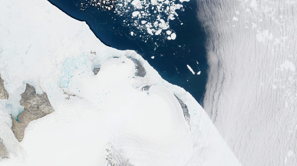
Featured image : Sentinel-2 acquisition over part of Greenland’s Flade Isblink Ice Cap on 5 July 2026. Contains modified Copernicus modified Copernicus Sentinel data (2026), processed by ESA.