
On 28 May 2025, a massive rock/ice avalanche detached from the Birch Glacier above the village of Blatten in the Lötschental valley (Valais, Switzerland). About 10 million cubic metres of rock and ice broke free, surged downslope and reached the valley floor, destroying the village and temporarily blocked the Lonza River. The sequence of events leading up to the collapse began with the detection of an initial rock slope failure on the flanks of the Kleines Nesthorn. This material accumulated on the surface of the Birch Glacier and subsequently, a combined rock/ice mass began to accelerate culminating in a large-scale failure.
The 2025 Blatten event is a stark reminder of the need to develop robust tools for anticipating and monitoring slope instabilities. In this case, local observations from authorities allowed preventive evacuation days before the collapse. However, installing local sensors on every alpine slope is logistically and financially unfeasible. This is where satellite-based remote sensing may offer a critical complement, providing regional-scale coverage, regular updates, and the ability to detect precursory movement, even in remote or inaccessible areas.
Satellite-based InSAR monitoring
Satellite-based Earth Observation has become an essential component of natural hazard monitoring, particularly in remote or inaccessible terrain. Among several technologies, Interferometric Synthetic Aperture Radar (InSAR) stands out for its ability to detect and measure ground deformation with precision, day and night, and in all weather conditions. By processing radar images acquired at different times, InSAR allows to identify subtle displacements over wide areas, often before they become visible or cause damage. This capability is especially valuable in mountainous regions like the Alps, where early signs of slope instability may be a precursor to sudden and catastrophic failure.
Over the past decade, the ESA Copernicus Sentinel-1 has become the backbone of satellite-based ground deformation monitoring in Europe. Operating in C-band and offering free, open-access data, the twin Sentinel-1 satellites have enabled systematic interferometric processing across vast areas. One of the most significant achievements is the European Ground Motion Service (EGMS), launched by the European Environment Agency and implemented by the Copernicus Programme. EGMS provides consistent, high-resolution maps of ground motion across the entire European continent, based on standardised processing of Sentinel-1 data. These products, updated annually and validated by national authorities, allow users to detect subsidence, landslides, tectonic motion, and infrastructure instability at millimetre precision. While EGMS represents a major step toward operational large-scale deformation monitoring, its reliance on C-band radar means it still faces challenges in densely vegetated areas, high alpine terrain, and when surface displacement rates exceed tens of centimetres every year.
L-band interferograms reveal instability at Kleines Nesthorn
In the aftermath of the rock/ice avalanche at Blatten, researchers conducted a targeted analysis within the framework of the MODULATE (MOnitoring lanDslides with mUltiplatform L-Band rAdar TEchniques) project. The project is funded by the Open Call under the ESA FutureEO programme.
The MODULATE team analysed archived radar data from ALOS-2 PALSAR-2 (JAXA, Japan) and SAOCOM (CONAE, Argentina) satellites, focusing on the slopes above Birch Glacier. By selecting specific image pairs from different time intervals, they were able to identify ground displacement signals dating back to 2017. A sequence of selected L-band interferograms (in the figure below) illustrates the evolution of surface motion.
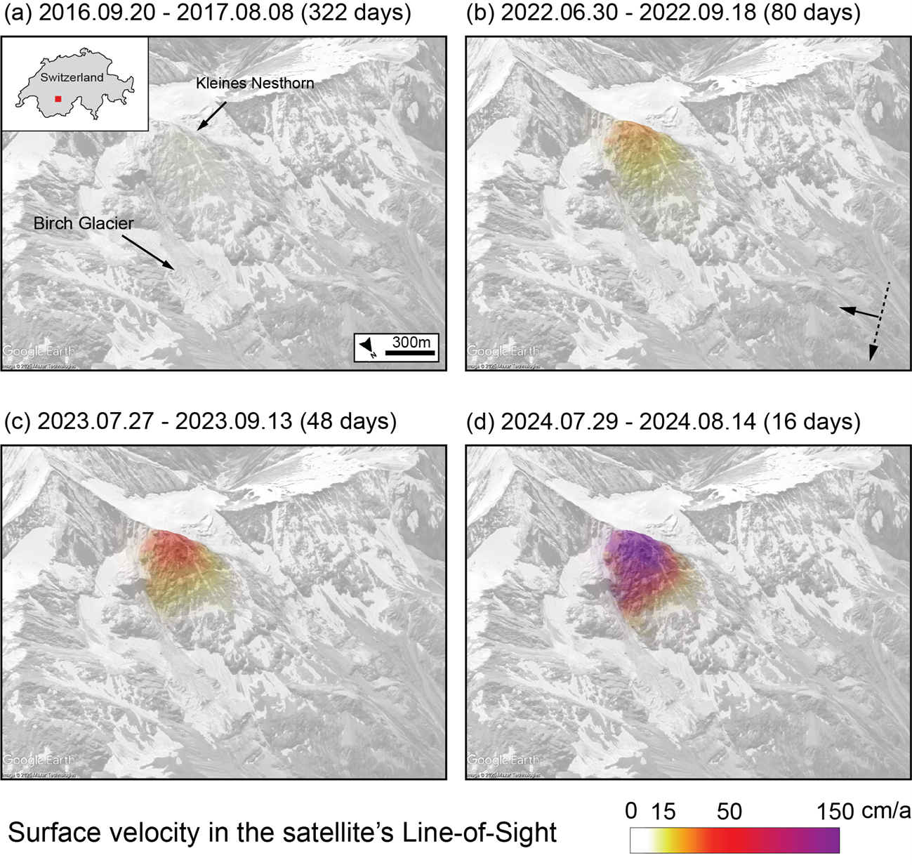
The earliest signal, detected between 2016 and 2017, reveals slow displacement on the flanks of Kleines Nesthorn. In subsequent years, however, deformation became more pronounced. By 2023, surface velocities had increased substantially, suggesting an acceleration phase up to 50 cm/a. In the last interferogram from August 2024, motion rates exceeded 150 cm/a, marking a clear transition from relatively slow to fast deformation and increasing the likelihood of a potential catastrophic failure. These results not only confirm the long-term development of the instability but also demonstrates the added value of L-band systems for detecting displacements where C-Band sensors often fail. While the interferograms were analysed retrospectively, they offer a valuable blueprint for developing future automated early detection systems.
Looking ahead: Toward systematic monitoring with L-band satellite radars
The findings from the Blatten case highlight how L-band radar systems can extend the capabilities of satellite-based monitoring in challenging terrain. In particular, the ability to detect displacement in vegetated, or otherwise low-coherence zones, underscores the value of integrating L-band observations into hazard monitoring frameworks. Combining L-band and C-band data supports a more complete picture of slope kinematics. This multi-sensor approach enhances our ability to characterize complex deformation patterns over time and space.
“Thanks to the long wavelength and strong coherence of the L-band SAR data, we were able to detect the patterns of deformation at the Kleines Nesthorn more easily than with conventional C-band radar systems,” says Tazio Strozzi, Principal Investigator of the MODULATE project at GAMMA Remote Sensing. “This example shows the potential added value of L-band data in high-altitude terrain.”
“Our analysis confirms that displacements at Kleines Nesthorn evolved for several years before the collapse,” explains Andrea Manconi from Climate Change, Extremes and Natural Hazards in Alpine Regions Research Centre CERC, part of WSL Institute for Snow and Avalanche Research SLF. “This kind of results help us think more clearly how satellite data can be used for early detection, but we still need to refine methods and improve accessibility if we want to support decision-makers timely.”
Although not yet operational, these findings show how L-band radar systems can reveal surface motion in conditions where C-band satellites like Sentinel-1 often face limitations. The insights gained from the MODULATE project show the importance of expanding Earth observation capabilities to better capture the early signs of slope instabilities that can precede events like the Blatten rock/ice avalanche. In this context, SAR missions such as the recently launched NASA–ISRO’s NISAR and the upcoming ESA’s ROSE-L are expected to play a key role. Equipped with advanced L-band radar systems and frequent revisit cycles, these missions will provide more consistent and reliable observations across challenging alpine terrain. By offering both wide-area surveys and targeted analysis, these next-generation satellites will enhance our ability to detect and interpret precursory ground motion in alpine areas. Combined with ongoing research efforts, they represent a step toward developing more robust, regionally scalable systems for hazard monitoring and early warning in high-mountain environments. Still, effective use of these tools will require not only technical capacity but also expert judgment to interpret ground motion in a geologically meaningful way.
Featured image : Rock/ice avalanche detached from the Birch Glacier above the village of Blatten (Valais, Switzerland) seen from Sentinel-2 on 30 May 2025. Contains modified Copernicus Sentinel data (2025), processed by ESA