A research in the context of the Irrigation+ project follow-on activity DTE Hydrology analysed the potential for inferring rainfall measurements from satellite data at higher resolution than the current usual one (10km).
In particular, it explored the application of the SM2RAIN (Soil Moisture to Rain) algorithm for rainfall estimation to a high resolution soil moisture product derived from Sentinel-1, named S1-RT1, characterized by 1 km spatial resolution (500 m spacing), and to the 25 km ASCAT soil moisture (12.5 km spacing), resampled to the same grid of S1-RT1. The study area was the Po River basin.
While the results show that good estimates of rainfall are obtainable from Sentinel-1 when considering aggregation time steps greater than 1 day, on average the ASCAT derived rainfall product performs better. Nonetheless, products obtained from Sentinel-1 outperform those from ASCAT in specific areas, like in valleys inside mountain regions and most of the plains, confirming the added value of the high spatial resolution information in obtaining spatially detailed rainfall.
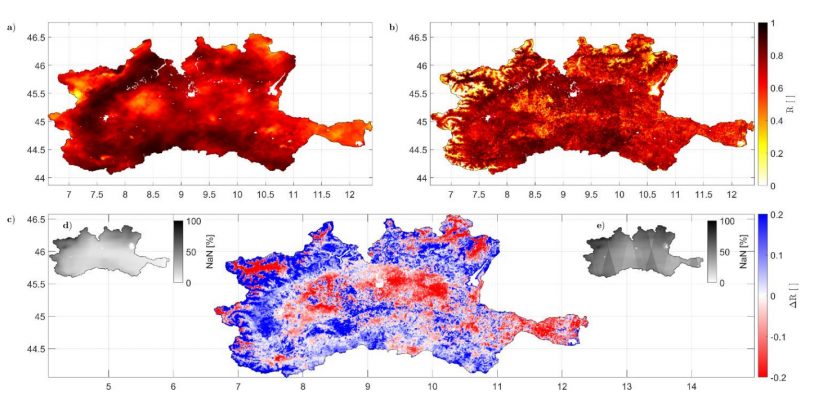
parameterized SM2RAIN to ASCAT (panel a) and to S1-RT1 (panel b) SM products. Panel c shows the difference between ASCAT and S1-RT1 correlation maps, while panel d) and e) show the percentage of not valid images per pixel respectively for ASCAT and S1-RT1.
Read about the full investigation in the recently published paper.
Filippucci, P., Brocca, L., Quast, R., Ciabatta, L., Saltalippi, C., Wagner, W., and Tarpanelli, A.: High resolution (1 km) satellite rainfall estimation from SM2RAIN applied to Sentinel-1: Po River Basin as case study, Hydrol. Earth Syst. Sci. Discuss. [preprint], https://doi.org/10.5194/hess-2021-563, in review, 2021