
Ocean currents are a key component to understanding many oceanic and climatic phenomena and furthermore the knowledge we have of them is crucial for navigation and operational applications. Therefore, a key problem in oceanography is the estimation of the synoptic (or “big picture”, large-scale, simultaneous conditions over a broad area) velocity field. Thanks to satellite and in situ observations combined with high-resolution numerical ocean models, new views and new knowledge of the global ocean surface dynamics that is filled with a large number of various mesoscale (~100 km) and submesoscale (< 10 km) meandering surface current features have emerged during the last decade. However, we are still faced with challenges when quantifying accurately the surface current associated with these mesoscale to submesoscale features, and nor it is always possible to provide sub-mesoscale forecasts of the exact locations and evolution of frontal features and eddies with sufficient accuracy. This deficiency results primarily from inability to adequately characterise the upper ocean dynamics. Nevertheless, during the last decade a more consistent quantitative use of satellite observations made possible to advance the understanding and reduce the knowledge gaps of the ocean surface current and upper layer dynamics at the mesoscale to submesoscale.
During the last years, there have been some works that began to exploit the synergy of different technologies, such us the combination of Sea Surface Temperature (SST) and altimetry measurements, in order to retrieved ocean surface currents. The reconstruction of surface currents from SST is based on deep physical principles that allow to convert SST into Sea Surface Height (SSH), from which currents can be directly calculated. The transfer function that transforms SST in SSH can be theoretically derived using Surface QuasiGeostrophic equations (SQG). Previous works showed the potential of microwave SST observations to reconstruct ocean surface currents using a synergistic approach: an optimal transfer function that combines the phase of SST with the SSH amplitude spectra. This synergistic approach revealed that surface quasi geostrophy (SQG) reconstruction can be enhanced and opened up the possibility to improve spatial resolution of ocean currents retrieved from altimeters observations if infrared SST observations are considered. However, these previous works employed measurements which were near in time but not simultaneous. Sentinel-3, as a multi-instrument mission, circumvents this temporal limitation by providing simultaneous measurements of SST and radar altimetry with high-end accuracy and reliability that can be combined synergistically to retrieve ocean surface currents at high spatial resolution. This was the main aim of OCEANUS, a Postdoctoral research project funded by the ESA’s Scientific Exploitation of Operational Missions Living Planet Fellowship.
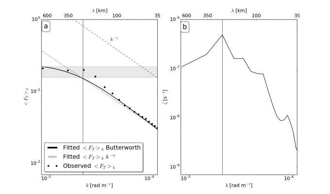
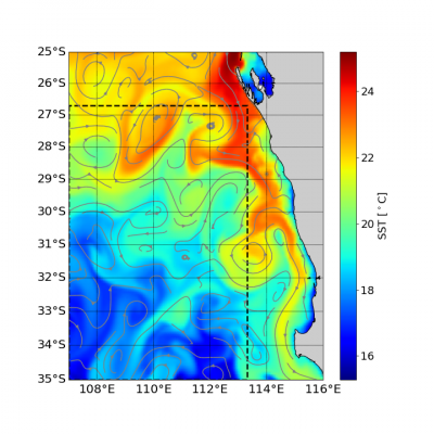
However, before applying this synergistic approach to satellite observations, we need to analyse and characterise the spectral properties of the transfer function. This spectral characterisation of the transfer function allows to exploit the synergy between SST and SSH observations that have different measurement topology and different spatial resolution. In this study, we performed a feasibility study using the daily outputs of the operational Mercator global analysis and forecast system at (1/12 °) in the western coast of Australia (27–35°S, 107–113°E) spanning from 26 November 2012 to 26 November 2016. Results showed that the mean transfer function in this region presents two well different bands: one characterized by a negative slope slightly steeper (k-1.2) than the k−1 predicted by the SQG solution for scales smaller than 270 km and another characterised by a plateau for wavelengths larger than 270 km. In addition, the results revealed that the inhomogeneity in dynamics of the flow limits global solutions. Finally, we showed that information contained along the track is enough for a synoptic reconstruction of the flow in this region, which shows the feasibility of applying this methodology to real satellite observations.
The full results of the study are reported in the peer-reviewed published article González-Haro, C., Isern-Fontanet, J.,Tandeo, P., & Garello, R. (2020). Ocean surface currents reconstruction: Spectral characterization of the transfer function between SST and SSH. Journal of Geophysical Research: Oceans, 125, e2019JC015958, https://doi.org/10.1029/2019JC015958 (open access).
Featured image : Sentinel-3 acquisition over western Australia. Contains modified Copernicus Sentinel data (2020)