According to the World Economic Forum the production of agriculture commodities including palm oil, soy, beef, timber, cocoa and rubber are accounting for the majority of deforestation world-wide. This ‘deforestation trajectory’ is directly associated with a growing carbon footprint of basic food staples therefore a wide range of new programmes and agribusinesses commitments emerge to reach the “zero net deforestation”.
One of the regions suffering from an uncontrolled expansion of soy and livestock is Chaco dry forest region in the South of Bolivia and Eastern part of Paraguay – countries which are experiencing one of the highest deforestation rates in the world. While agriculture production is one of the most important sectors in regional economy, according to the World Bank, the fear is that if the impact of agriculture production on deforestation is sustained there will be millions of additional hectares lost by 2030.
To address this situation, a number of innovative programmes have been put in place to increase agricultural productivity and enhance food security while mitigating deforestation. The Inter-American Development Bank (IDB) is, for example, currently providing financing and technical aid to the government of Bolivia to tackle the underlying root causes of deforestation from agriculture commodities by setting up an environmental cadastre. It is aimed to address land tenure control issues resulting from unbridled soy and livestock expansion causing deforestation and ecosystem degradation. The GEF-financed Green Commodities Programme, led by UNDP, is on the other hand, promoting an integrated supply chain approach and landscape level analysis for beef production in Paraguay.
A better view on agriculture in South America
A recent episode of ESA “Earth from Space” highlighted the capabilities of Sentinel 2 to identify agriculture production patterns in the Bolivia’s Santa Cruz area. While Paraguay and Bolivia currently monitor deforestation on an annual basis using optical imagery, for agricultural production area licensing and commodity monitoring more frequent observation is required by the local policymakers and government agencies to help them design more sustainable policies in existing agricultural areas.
The ESA EO4SD (Earth Observation for Sustainable Development) initiative provided important improvement in data collection concerning habitat quality, deforestation and crop distribution and performance.
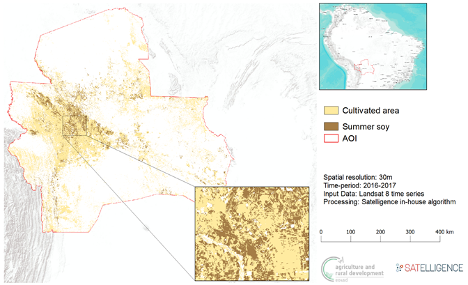
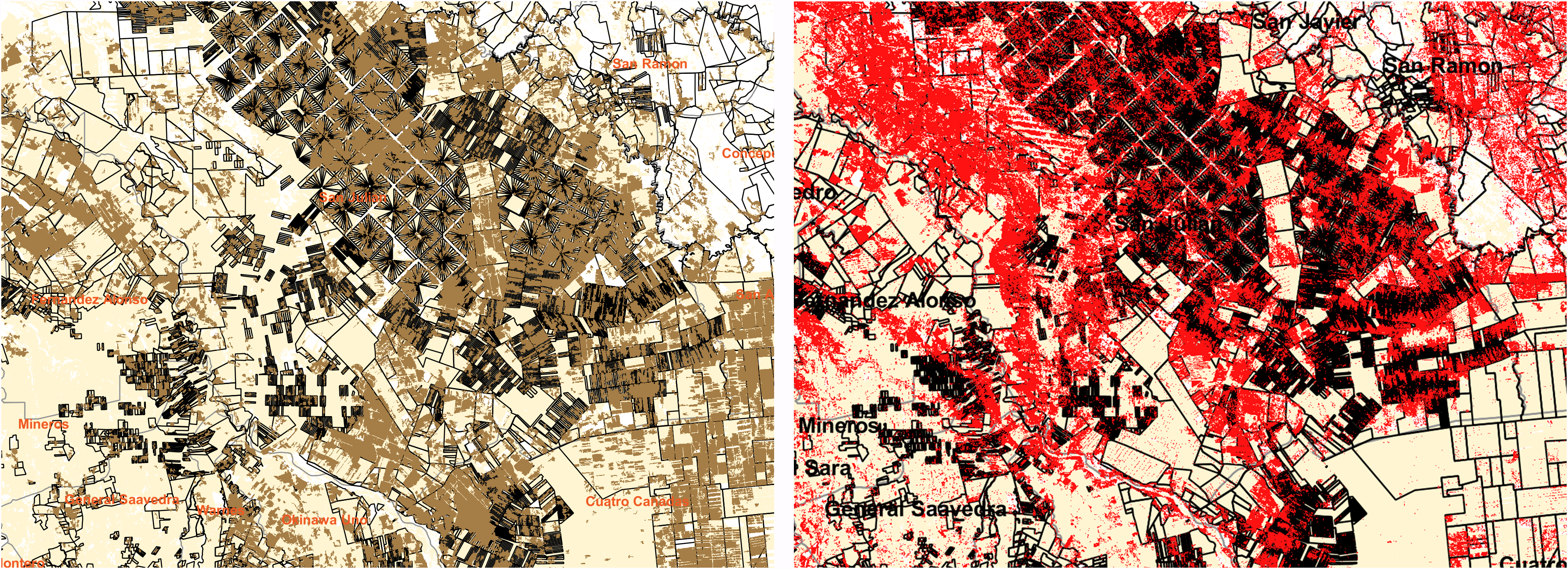
The image below displays sample results from a large scale mapping an entire Santa Cruz region in Bolivia, discriminating cultivated area from other land use and pinpointing summer soy.
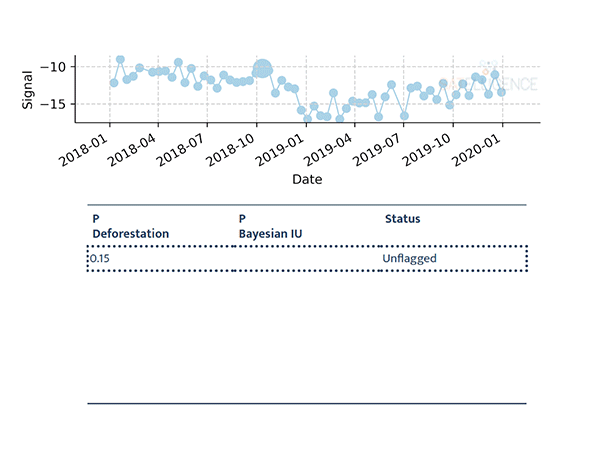
The processing was done using Sentinel-1, Sentinel-2 and Landsat data and an iterative Bayesian Updating Machine Learning approach; a method that was first applied to radar satellite images for deforestation detection by Wageningen University, in collaboration with Satelligence. In short, this method calculates the probability that an area is deforested and “stacks” these probabilities in an iterative way to have a higher degree of certainty about the deforestation event. The method first ‘flags’ pixels as possibly deforested, which can be confirmed or rejected with a later measurement. Such probabilistic approach coupled with Sentinel and Landsat data fusion has allowed to overcome a well-known challenge in monitoring of dry forest ecosystems due to the seasonality of the green forest cover.
The figure below shows an Bayesian updating in action:
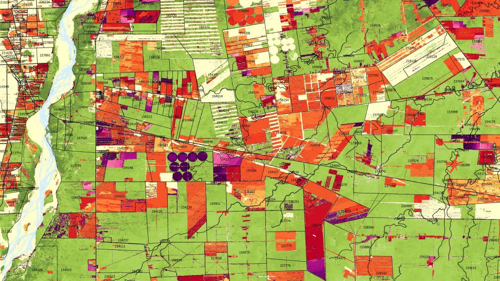
Moreover, the satellite processing results were coupled with a large agricultural parcel database of almost 500,000 land titles in Bolivia, in particular, the cities of Santa Cruz and Cochambaba.
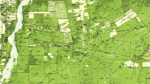
The power of combining data sources is clearly visible in the images below: cultivated area / soy maps and deforestation mapped from satellite are overlaid on land ownership parcel data, making it possible to link where the production of soy is related to deforestation. This potentially leads to improved informed land allocation and can help promote sustainable agricultural expansion in less vulnerable areas.
Going forward, the commitment to “greening” commodity supply chains will require operational availability of satellite-based services implemented at large scale and customised to specific ecosystem types and land governance processes. ESA is continuously working with the development community to demonstrate the capabilities of the European service industry to enable research and development of advanced data analytics and data infrastructures that can deliver required impact at scale.
Learn more about EO4SD Agriculture and the Bayesian updating method for EO data classification.