UK Centre for Ecology & Hydrology (GB)
FluViSat is a proof-of-concept study that demonstrates the potential of satellite-collected video imagery to provide accurate and timely quantification of water movements and river flows for the benefit of water management globally. The study is being led by the UK Centre for Ecology and Hydrology, in partnership with the Luxembourg-based company, RSS-Hydro, and the Queensland Government, Australia.
According to the OECD, floods affect 250 million people and cause 40 billion USD in losses on an annual basis. In addition, the demand for water for people, industry and agriculture is continually growing, placing severe stress on water availability. Freshwater management requires quantitative observations of how much water is flowing through and is being stored within river catchments, and yet across much of the world, water monitoring capabilities fall short of requirements.
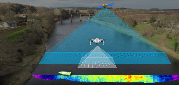
Previous efforts to determine river discharge from Earth Observation (EO) data have largely been based on the determination of water surface height and extent alone, and lacked the critical parameter of flow speed. Two recent advances are leveraged by the FluViSat project to bring a step change to satellite based river flow observation capabilities. The first is the availability of large satellite networks, such as the SkySat constellation operated by Planet Labs that combine very high-resolution imagery with frequent revisit times. The second is the development of digital video-based ‘surface velocimetry’ methods for streamflow determination. Surface-velocimetry techniques work by tracking the movement of visible features on the water’s surface through the frame of digital video files, in order to quantify the movement of flowing water.
By combining these surface-velocimetry techniques with very high resolution video from the SkySat satellites, the FluViSat project has demonstrated that the speed of flow of water on the Earth’s surface can be accurately determined for a range of river sizes, types and locations. This in turn greatly improves the accuracy of remote observations of river discharge and flood peaks.
The primary customers for this innovation are water resource managers, environmental regulators, and those involved risk and disaster mitigation and management. However, the successful proof of concept can also be beneficial to the re-insurance community, hydro-meteorological systems modellers, as well the EO data service providers.
***
Following the successful demonstration of the FluViSat satellite velocimetry innovation, an extension was granted to expand the proof-of-concept to explore the validity of using high framerate still imagery from space to estimate surface flow rates. The team is also leveraging the existing ESA Earthnet project PP0087756 titled “Measuring global streamflow and drought impacts with Planet SkySat ultra-high resolution satellite imagery” to explore the potential of still frame imagery from Planet Labs, who will also be providing video imagery to help validate results from the still frame images. The extension period is being used to refine the FluViSat video method, in particular the pre-processing of imagery (both video and still frame) to expand the range of locations and conditions in which the methods can be used, and to increase the accuracy of velocimetry results. Finally, the project is trying to develop a framework to enable responsive satellite-based observations when extreme hydrometeorological events occur.