GeoVille (AT)
EO Clinic support requested by: UNDP Gaza Office / Programme of Assistance to the Palestinian People (PAPP)
Requesting activity: Building Capacities in Remote Sensing Technologies in the Gaza Strip
Requesting activity type: Technical Assistance (TA)
EO Clinic relevant Thematic Groups: TG2 (Climate Change), TG3 (Coastal Zone Management), TG4 (Disaster Risk Management), TG9 (Urban)
Work Order number: EOC0011
Work Order status: Completed
Work Order start: 2020 Aug 18
Work Order end: 2020 Sep 29
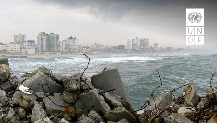
In the recent years, the Gaza Strip has been experiencing rapidly-evolving environmental changes, related especially to land use, coastal erosion and agricultural production, in conjunction with flooding and drought problems. Due to the lack of planning and monitoring by different stakeholders, this has led to serious and complex problems, including risk to residents in coastal areas and food insecurity. Monitoring and detection of such environmental changes and assessment of their trends as well as their consequences are necessary for future development.
UNDP is working to launch projects on the protection of the Gaza shoreline, where detailed information is needed on the forces driving the coastal erosion, which was observed historically and is expected to continue in the coming years. Without adequate measures, this is considered as a real risk for the coastal environments and the residents living near the shoreline, especially in the western side of the Gaza Strip. This also causes considerable economic loss for the people of Gaza.
In general, in Palestine and the Gaza Strip the approach of inclusion of remote sensing and satellite Earth Observation (EO) in planning and monitoring activities is still in its early stages, due mainly to the limited number of remote sensing specialists. There is a pressing need to mainstream the culture of remote sensing in the context of Palestine and specifically in the Gaza Strip, where changes are sometimes manmade and can be massive. UNDP is planning an intervention aiming to increase the local capacities in utilising remote sensing in planning and monitoring the different rehabilitation and development activities aiming to overcome relevant knowledge gaps.
The supported UNDP project aims to build capacities in remote sensing applications for sustainable development in the Gaza Strip. The present EO Clinic support will contribute to creating a complete and up-to-date analysis of the Gaza shoreline, providing insights in coastal erosion and accretion processes and associated risks. Additionally, it will contribute to the UNDP-supported training programme by providing high-quality EO training materials and support in delivering those trainings.