GRASP-SAS (FR)
Project overview
AIRSENSE’s main objective is to enhance the understanding of aerosol and aerosol-cloud interactions. This activity is part of Atmosphere Science Cluster of ESA’s EO Science for Society programme, an element of the ESA FutureEO programme, which aims at boosting Europe’s excellence in EO science and its applications.
One of the goals of this programme is to establish a strong coordinated scientific effort in Europe on Aerosol and Aerosol/Cloud interaction research by promoting a cooperation between activities launched by ESA and the European Commission (EC), in particular with CLEANCLOUD and CERTAINTY projects that were selected under the EC Horizon Europe Call “Improved knowledge in cloud-aerosol interaction” (HORIZON-CL5-2023-D1-01-04).
AIRSENSE objectives
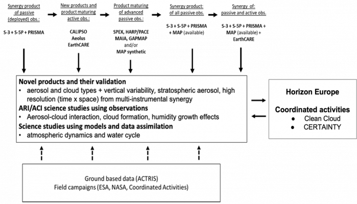
AIRSENSE sensors
| Platform/
Instrument name |
Spectral coverage | Polarization capability | Resolution | Swath/
Coverage |
Operational |
| Polar orbiting passive instruments | |||||
| Sentinel-3A,-3B/ OLCI | VIS, NIR | no | ~300 m | ~1270 km | 2016-present |
| S5p/TROPOMI | UV, VIS, NIR, SWIR (hyperspectral) | no | ~7×3.5 km | ~2600 km | 2017-present |
| PRISMA | VIS, NIR, SWIR
(hyperspectral) |
no | ~20 m | Target selected | 2019-present |
| Sentinel-2A,-2B | VIS, NIR, SWIR | no | ~10 m | 290 km | 2015-present |
| POLDER | VIS, NIR | MAP | ~6 km | 1600 km | 2005–2013 |
| SPEXone/PACE, HARP-2/PACE | UV, VIS, NIR | MAP | ~ 5.2 km | ~100 km – 2200 km | 2024- |
| GAPMAP | VIS, NIR | MAP | ~ 1-6 km | Target selected | 2023-present |
| EarthCARE/
MSI |
VIS, NIR, SWIR, TIR | no | ~500 m | ~150 km | 2024- |
| PACE/OCI | VIS, NIR, SWIR | no | ~1 km | 2700 km | 2024- |
| Geostationary passive instruments | |||||
| HIMAWARI/AHI | VIS, NIR, SWIR | no | 500 m-2 km
(10 min) |
Full disk, 140.7°E | 2014-present |
| MTG-I/FCI | VIS, NIR, SWIR | no | 500 m-2 km
(10 min) |
Full disk,
0.0° |
2023-present |
| Polar-orbiting active instruments | |||||
| EarthCARE/ATLID | UV (HSRL) | depolarisation | 103 m
(vertical) |
– | 2024- |
| Aeolus/ALADIN | UV (HSRL) | no | 500-2000 m
(vertical) |
– | 2018-2023 |
| CALIPSO/CALIOP | VIS, IR | depolarisation | 60m
(vertical) |
– | 2006-2023 |
| Ground-based instruments and networks | |||||
| PollyNET/ACTRIS/EARLINET | UV,VIS,IR | depolarisation | >30 m
(vertical) |
Worldwide/
Europe |
2000-present |
| AERONET | UV,VIS,NIR,SWIR | MAP | every 15 min | Worldwide | 1993-present |
| Field campaigns | |||||
| Variety of available and future field campaigns* | UV, VIS, NIR, SWIR | MAP, depolarisation | >30 m
(vertical) <60m MAP |
Target selected | Target selected |
Publications
Amiridis, V. et al.: LIVAS: a 3-D multi-wavelength aerosol/cloud database based on CALIPSO and EARLINET, Atmos. Chem. Phys., 15, 7127–7153, https://doi.org/10.5194/acp-15-7127-2015, 2015.
Chen, C. et al.: Properties of aerosol and surface derived from OLCI/Sentinel-3A using GRASP approach: Retrieval development and preliminary validation, Remote Sens. Environ., 280, 113142, https://doi.org/10.1016/j.rse.2022.113142, 2022a.
Chen, C. et al.: Multi-angular polarimetric remote sensing to pinpoint global aerosol absorption and direct radiative forcing. Nat. Commun., 13, 7459, https://doi.org/10.1038/s41467-022-35147-y, 2022b.
Chen, C. et al.: Aerosol and Surface Retrieval from S5P/TROPOMI with GRASP Algorithm. Part II: Global Validation and Intercomparison, Remote Sens. Environ., submitted, 2023.
Dubovik, O. et al.: Synergy of PARASOL and CALIOP observations using GRASP algorithm for enhanced aerosol characterisation. In AGU Fall Meeting Abstracts (Vol. 2019, pp. A23B-05), 2019.
Dubovik, O. et al.: A comprehensive description of multi-term LSM for applying multiple a priori constraints in problems of atmospheric remote sensing: GRASP algorithm, concept, and applications, Front. Remote Sens., 2, 23, https://doi.org/10.3389/frsen.2021.706851, 2021a.
Dubovik, O. et al.: Grand challenges in satellite remote sensing, Front. Remote Sens., 2, 619818, https://doi.org/10.3389/frsen.2021.619818, 2021b.
Hasekamp, O. P. et al.: Aerosol measurements by SPEXone on the NASA PACE mission: expected retrieval capabilities, J. Quant. Spectrosc. Radiat. Transf., 227, 170–184, https://doi.org/10.1016/j.jqsrt.2019.02.006, 2019.
Litvinov, P. et al.: New Possibilities For Air Quality Monitoring From Space-Borne Remote Sensing: Application Of GRASP Algorithm To S5p/TROPOMI and PRISMA Measurements, ATMOS-2021, 2021.
Litvinov, P. et al.: Surface Validation Dataset in Worldwide Locations Based on the Synergetic Retrieval from Satellite and Ground Based Measurements, AGU Fall Meeting 2022, Chicago, 12-16 December 2022.
Litvinov, P. et al: Multi-instrument synergetic retrieval for aerosol/surface characterization and validation with GRASP algorithm. APOLO, May, 2023a.
Lopatin, A. et al.: Synergy processing of diverse ground-based remote sensing and in situ data using the GRASP algorithm: applications to radiometer, lidar and radiosonde observations, Atmos. Meas. Tech., 14, 2575–2614, https://doi.org/10.5194/amt-14-2575-2021, 2021.
Wandinger, U., et al.: HETEAC – the Hybrid End-To-End Aerosol Classification model for EarthCARE, Atmos. Meas. Tech., 16, 2485–2510, https://doi.org/10.5194/amt-16-2485-2023, 2023a.
Wandinger, U. et al.: Cloud top heights and aerosol layer properties from EarthCARE lidar observations: the A-CTH and A-ALD products, EGUsphere [preprint], https://doi.org/10.5194/egusphere-2023-748, 2023.
Aerosol Retrievals From SPEXone on the NASA PACE Mission: First Results and Validation
Geophysical Research Letters (2025)
Aerosol Retrievals From SPEXone on the NASA PACE Mission: First Results and Validation
Geophysical Research Letters (2025)
Journal of Geophysical Research: Atmospheres (2024)