Africa, the Earth’s second largest continent, with its rapidly growing populations and economies requires up-to-date and timely geospatial information on its natural resources and economic activities. This demand has most recently been further emphasized by the dominance of the top five global risks of the 2020 World Economic Forum Global Risks Report by climate-related issues. The recent African Space Policy and Strategy recognises the need to make best use of space assets for monitoring and implementing national-to-continental sustainable development policies in Africa. The African Union 2063 Agenda and the UN Sustainable Development Goals (SDG) comprehensively define the information required for progress on sustainable development in Africa and globally: many of them can be monitored by Earth Observation (EO).
The European Commission has recently proposed an African-European partnership for the digital transformation of the continent as part of their strategy with Africa. Earth Observation from space is identified as essential digital technology providing information for evidence-based policy and decision making. Indeed, the advent of the European Copernicus program and its observations collected by its Sentinel satellites offer unprecedented open and free data amounting up to 1.2 petabytes per year over the African continent. The Sentinel-1 and -2 missions can provide geospatial information relevant for natural resources monitoring in a timely fashion and at high resolution.
The vast amount of free data to be processed and analysed requires adoption of the latest digital tools such as cloud computing and innovative machine learning techniques. This will enable full EO data access and usage across Africa, overcoming low-bandwidth and infrastructure bottlenecks that still persist across the continent.
EO AFRICA is driven by African user needs and follows a long-term vision (>10 years) for the emergent digital era in Africa. It builds on 17 years of experience gained through the ESA TIGER initiative and its African network of EO experts, and aims to facilitate the sustainable adoption of Earth Observation and related space technology in Africa.
Main objectives:
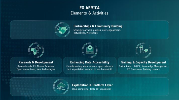
- Use Strategic Partnerships with the African Union Commission (AUC) and national African organisations (e.g. SANSA), relevant UN Agencies and the European Commission (DG-INTPA/DEFIS/JRC)
- Ensure African Ownership by building awareness and credibility in EO technology within countries and development stakeholders and engaging African national authorities, institutions and the private sector
- Leverage on Cloud Computing technology for a comprehensive EO data accessibility and exploitation in Africa – leapfrogging infrastructure bottlenecks
- Develop and support EO knowledge transfer to Africans, assisting African technical centers to exploit fully existing EO technologies and data.
- Facilitate European-Africa R&D collaborations to evolve and innovate EO applications with Africans making full use of data analytics solutions and Big Data concepts, focusing on thematic with particular urgency such as water scarcity and food security
Digital Solutions will facilitate and promote Data Analytics platform services to African users, offer re-hosted solutions at African Cloud Resources and contribute to the development of data analytics solutions with low bandwidth consumption and interface suitable for hand-held mobile devices.
Research Themes:
- Agriculture and Food Security: Precision agriculture, crop yield modelling, pest and disease monitoring, resilience analysis.
- Disaster Risk Reduction and Response: Early warning systems, impact forecasting, vulnerability mapping.
- Urban Development and Infrastructure: Urban change detection, infrastructure monitoring, classification of informal settlements.
- Health and Epidemiology: Research on disease vectors, pollution exposure, environmental health correlations.
- Energy and Natural Resource Management: Mapping renewable energy potential, forest/water resources management, monitoring extractive activities.
- Climate Change and Natural Capital: Ecosystem degradation research, climate impact modelling, carbon tracking.
- Coastal and Marine Monitoring: Fisheries management, coastal erosion monitoring, marine ecosystem assessments.
- Calibration and Validation (Cal/Val): Deploying in-situ sensors, organizing field campaigns to improve EO product accuracy.